Walahir geodata
Walahir (West Java) is a seat of a fourth-order administrative division; located in Indonesia in Asia/Jakarta (GMT+7) time zone. In our database, there are 407 cities with bigger population. Compared to other cities in Indonesia, 54.5% of cities are located further ↑North; 72.3% of cities are located further →East and 67.7% of cities have lower elevation than Walahir. Note1


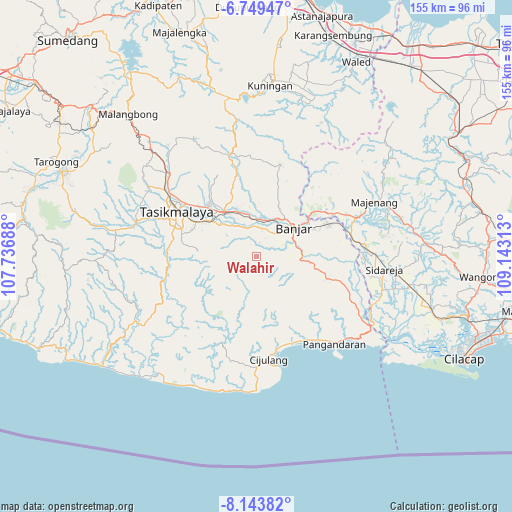
Walahir GPS coordinates[2]
7° 26' 49.92" South, 108° 26' 24" East
| Map corner | latitude | longitude |
|---|---|---|
| Upper-left | -6.74947°, | 107.73688° |
| Center: | -7.4472°, | 108.44° |
| Lower-right: | -8.14382°, | 109.14313° |
| Map W x H: | 155×155 km | = 96.3×96.3mi |
| max Lat: | 5.88969° ⇑54.5% North |
| Walahir: | -7.4472° |
| min Lat: | ⇓45.5% South -10.934° |
| min Long | Walahir | max Long |
| 95.1345° | 108.44° | 140.9419° |
| W 27.7%⇐ | ⇒72.3% E |
Elevation
Elevation of Walahir is 259 m = 850 ft, and this is 29.3 m = 96 ft above average elevation for this country.
| Max E: |
3185 m = 10449 ft | 32.3% |
| Walahir | 259 m 850 ft | |
| Avg. | 229.7 m = 754 ft | |
Min E: |
-1 m = -3 ft | 67.7% |
See also: Indonesia elevation on elevation.city.
Geographical zone
Walahir is located in South Torrid zone (between Equator and Tropic of Capricorn). Distance of Equator is 828.1 km =514.6 mi to North.| Distance of | km | miles | from Walahir |
|---|---|---|---|
| Equator | 828.1 | 514.6 | to North |
| Tropic Capricorn | 1777.9 | 1104.7 | to South |
| Antarctic Circle | 6573.1 | 4084.3 | to South |
| South Pole | 9179 | 5703.6 | to South |


Nearby cities:
15 places around Walahir: (largest is in red/bold)
• Bojongmalang
6 km =3.7 mi,  25°
25°
• Bunirasa
4.1 km =2.5 mi,  12°
12°
• Cilangkap
8 km =5 mi,  53°
53°
• Cimarga
2.8 km =1.7 mi,  95°
95°
• Ciparay
4.5 km =2.8 mi,  56°
56°
• Ciwarulang
6.6 km =4.1 mi,  306°
306°
• Gandapura
6.4 km =4 mi,  342°
342°
• Kalangsari
5.4 km =3.4 mi,  198°
198°
• Karangpete
5.2 km =3.2 mi,  293°
293°
• Karangsirna
7.2 km =4.5 mi, 293°
• Limusnunggal
7.6 km =4.7 mi,  213°
213°
• Malabar
5.4 km =3.4 mi,  145°
145°
• Raksabaya
7.7 km =4.8 mi, 13°
• Sukadana
7.4 km =4.6 mi,  328°
328°
• Sukajaya
3.1 km =1.9 mi,  259°
259°
Sources, notices
• [Note1] Compared only with cities in Indonesia existing in our database
• [Src1] Map data: © OpenStreetMap contributors (CC-BY-SA)
• [Src2] Other city data from geonames.org with taken over terms of usage.
• [Src3] Geographical zone / Annual Mean Temperature by Robert A. Rohde @ Wikipedia
