Gandapura geodata
Gandapura (West Java) is a seat of a fourth-order administrative division; located in Indonesia in Asia/Jakarta (GMT+7) time zone. In our database, there are 407 cities with bigger population. Compared to other cities in Indonesia, 53% of cities are located further ↑North; 72.6% of cities are located further →East and 63.3% of cities have lower elevation than Gandapura. Note1


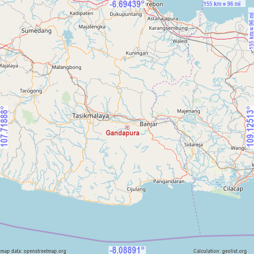
Gandapura GPS coordinates[2]
7° 23' 31.92" South, 108° 25' 19.2" East
| Map corner | latitude | longitude |
|---|---|---|
| Upper-left | -6.69439°, | 107.71888° |
| Center: | -7.3922°, | 108.422° |
| Lower-right: | -8.08891°, | 109.12513° |
| Map W x H: | 155.1×155.1 km | = 96.4×96.4mi |
| max Lat: | 5.88969° ⇑53% North |
| Gandapura: | -7.3922° |
| min Lat: | ⇓47% South -10.934° |
| min Long | Gandapura | max Long |
| 95.1345° | 108.422° | 140.9419° |
| W 27.4%⇐ | ⇒72.6% E |
Elevation
Elevation of Gandapura is 201 m = 659 ft, and this is 28.7 m = 94 ft below average elevation for this country.
| Max E: |
3185 m = 10449 ft | 36.7% |
| Avg. | 229.7 m = 754 ft | |
| Gandapura | 201 m = 659 ft | |
Min E: |
-1 m = -3 ft | 63.3% |
See also: Indonesia elevation on elevation.city.
Geographical zone
Gandapura is located in South Torrid zone (between Equator and Tropic of Capricorn). Distance of Equator is 821.9 km =510.7 mi to North.| Distance of | km | miles | from Gandapura |
|---|---|---|---|
| Equator | 821.9 | 510.7 | to North |
| Tropic Capricorn | 1784 | 1108.5 | to South |
| Antarctic Circle | 6579.2 | 4088.1 | to South |
| South Pole | 9185.1 | 5707.4 | to South |


Nearby cities:
15 places around Gandapura: (largest is in red/bold)
• Ancol
4.9 km =3 mi,  308°
308°
• Bojong
5.2 km =3.2 mi,  11°
11°
• Bojongmalang
4.6 km =2.9 mi,  98°
98°
• Bunirasa
3.6 km =2.2 mi,  125°
125°
• Ciharalang
4.8 km =3 mi,  345°
345°
• Cimaragas
5 km =3.1 mi,  63°
63°
• Cinangsih Satu
4.1 km =2.5 mi,  289°
289°
• Ciwarulang
4 km =2.5 mi,  236°
236°
• Karangpete
4.9 km =3 mi,  214°
214°
• Karangsirna
5.7 km =3.5 mi,  234°
234°
• Pasirnangka
3.4 km =2.1 mi,  29°
29°
• Raksabaya
4 km =2.5 mi,  70°
70°
• Sindangrasa
4.9 km =3 mi,  268°
268°
• Sukadana
1.9 km =1.2 mi,  275°
275°
• Walahir
6.4 km =4 mi,  162°
162°
Sources, notices
• [Note1] Compared only with cities in Indonesia existing in our database
• [Src1] Map data: © OpenStreetMap contributors (CC-BY-SA)
• [Src2] Other city data from geonames.org with taken over terms of usage.
• [Src3] Geographical zone / Annual Mean Temperature by Robert A. Rohde @ Wikipedia
