Parung geodata
Parung (West Java) is a seat of a fourth-order administrative division; located in Indonesia in Asia/Jakarta (GMT+7) time zone. In our database, there are 407 cities with bigger population. Compared to other cities in Indonesia, 65.7% of cities are located further ↓South; 73% of cities are located further →East and 93.5% of cities have lower elevation than Parung. Note1


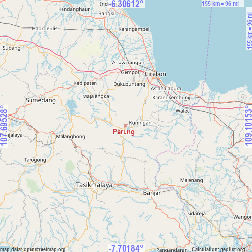
Parung GPS coordinates[2]
7° 0' 16.2" South, 108° 23' 54.24" East
| Map corner | latitude | longitude |
|---|---|---|
| Upper-left | -6.30612°, | 107.69528° |
| Center: | -7.0045°, | 108.3984° |
| Lower-right: | -7.70184°, | 109.10153° |
| Map W x H: | 155.2×155.2 km | = 96.4×96.4mi |
| max Lat: | 5.88969° ⇑34.3% North |
| Parung: | -7.0045° |
| min Lat: | ⇓65.7% South -10.934° |
| min Long | Parung | max Long |
| 95.1345° | 108.3984° | 140.9419° |
| W 27%⇐ | ⇒73% E |
Elevation
Elevation of Parung is 749 m = 2457 ft, and this is 519.3 m = 1704 ft above average elevation for this country.
| Max E: |
3185 m = 10449 ft | 6.5% |
| Parung | 749 m 2457 ft | |
| Avg. | 229.7 m = 754 ft | |
Min E: |
-1 m = -3 ft | 93.5% |
See also: Indonesia elevation on elevation.city.
Geographical zone
Parung is located in South Torrid zone (between Equator and Tropic of Capricorn). Distance of Equator is 778.8 km =483.9 mi to North.| Distance of | km | miles | from Parung |
|---|---|---|---|
| Equator | 778.8 | 483.9 | to North |
| Tropic Capricorn | 1827.1 | 1135.3 | to South |
| Antarctic Circle | 6622.3 | 4114.9 | to South |
| South Pole | 9228.2 | 5734.1 | to South |


Nearby cities:
15 places around Parung: (largest is in red/bold)
• Cibengang
3.8 km =2.4 mi,  186°
186°
• Cidulang
3.1 km =1.9 mi,  255°
255°
• Cikijing
3.8 km =2.4 mi,  249°
249°
• Cikupa
0.3 km =0.2 mi,  202°
202°
• Cipasung
1.4 km =0.9 mi, 197°
• Darma
0.6 km =0.4 mi,  90°
90°
• Haurkuning
3.9 km =2.4 mi,  113°
113°
• Jagara
2.2 km =1.4 mi,  104°
104°
• Jagasari
3.4 km =2.1 mi,  266°
266°
• Kaliwon Kertawirama
3.3 km =2.1 mi, 103°
• Kawahmanuk
1.1 km =0.7 mi,  215°
215°
• Paninggaran
1.9 km =1.2 mi,  166°
166°
• Sakerta Barat
3.4 km =2.1 mi, 166°
• Sakerta Timur
4.1 km =2.5 mi,  151°
151°
• Sindangpanji
2.7 km =1.7 mi,  227°
227°
Sources, notices
• [Note1] Compared only with cities in Indonesia existing in our database
• [Src1] Map data: © OpenStreetMap contributors (CC-BY-SA)
• [Src2] Other city data from geonames.org with taken over terms of usage.
• [Src3] Geographical zone / Annual Mean Temperature by Robert A. Rohde @ Wikipedia
