Jagara geodata
Jagara (West Java) is a seat of a fourth-order administrative division; located in Indonesia in Asia/Jakarta (GMT+7) time zone. In our database, there are 407 cities with bigger population. Compared to other cities in Indonesia, 65.3% of cities are located further ↓South; 72.7% of cities are located further →East and 92.2% of cities have lower elevation than Jagara. Note1


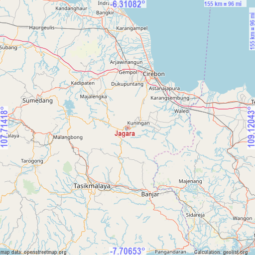
Jagara GPS coordinates[2]
7° 0' 33.12" South, 108° 25' 2.28" East
| Map corner | latitude | longitude |
|---|---|---|
| Upper-left | -6.31082°, | 107.71418° |
| Center: | -7.0092°, | 108.4173° |
| Lower-right: | -7.70653°, | 109.12043° |
| Map W x H: | 155.2×155.2 km | = 96.4×96.4mi |
| max Lat: | 5.88969° ⇑34.7% North |
| Jagara: | -7.0092° |
| min Lat: | ⇓65.3% South -10.934° |
| min Long | Jagara | max Long |
| 95.1345° | 108.4173° | 140.9419° |
| W 27.3%⇐ | ⇒72.7% E |
Elevation
Elevation of Jagara is 715 m = 2346 ft, and this is 485.3 m = 1592 ft above average elevation for this country.
| Max E: |
3185 m = 10449 ft | 7.8% |
| Jagara | 715 m 2346 ft | |
| Avg. | 229.7 m = 754 ft | |
Min E: |
-1 m = -3 ft | 92.2% |
See also: Indonesia elevation on elevation.city.
Geographical zone
Jagara is located in South Torrid zone (between Equator and Tropic of Capricorn). Distance of Equator is 779.3 km =484.2 mi to North.| Distance of | km | miles | from Jagara |
|---|---|---|---|
| Equator | 779.3 | 484.2 | to North |
| Tropic Capricorn | 1826.6 | 1135 | to South |
| Antarctic Circle | 6621.8 | 4114.6 | to South |
| South Pole | 9227.7 | 5733.8 | to South |


Nearby cities:
15 places around Jagara: (largest is in red/bold)
• Babatan
4.2 km =2.6 mi,  78°
78°
• Cikupa
2.2 km =1.4 mi,  277°
277°
• Cipasung
2.6 km =1.6 mi,  252°
252°
• Darma
1.6 km =1 mi,  288°
288°
• Haurkuning
1.8 km =1.1 mi,  124°
124°
• Kadugede
4.1 km =2.5 mi, 82°
• Kaliwon Kertawirama
1.1 km =0.7 mi,  101°
101°
• Kawahmanuk
2.7 km =1.7 mi,  262°
262°
• Kertayuga
3.2 km =2 mi,  135°
135°
• Nusaherang
3 km =1.9 mi,  90°
90°
• Paninggaran
2.1 km =1.3 mi,  231°
231°
• Parung
2.2 km =1.4 mi, 284°
• Sakerta Barat
3.1 km =1.9 mi,  205°
205°
• Sakerta Timur
3.1 km =1.9 mi,  182°
182°
• Windusari
3.3 km =2.1 mi,  110°
110°
Sources, notices
• [Note1] Compared only with cities in Indonesia existing in our database
• [Src1] Map data: © OpenStreetMap contributors (CC-BY-SA)
• [Src2] Other city data from geonames.org with taken over terms of usage.
• [Src3] Geographical zone / Annual Mean Temperature by Robert A. Rohde @ Wikipedia
