Selajambe Satu geodata
Selajambe Satu (West Java) is a seat of a fourth-order administrative division; located in Indonesia in Asia/Jakarta (GMT+7) time zone. In our database, there are 407 cities with bigger population. Compared to other cities in Indonesia, 59.1% of cities are located further ↓South; 72% of cities are located further →East and 71.1% of cities have lower elevation than Selajambe Satu. Note1


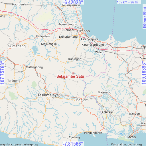
Selajambe Satu GPS coordinates[2]
7° 7' 6.6" South, 108° 27' 38.88" East
| Map corner | latitude | longitude |
|---|---|---|
| Upper-left | -6.42028°, | 107.75768° |
| Center: | -7.1185°, | 108.4608° |
| Lower-right: | -7.81566°, | 109.16393° |
| Map W x H: | 155.2×155.2 km | = 96.4×96.4mi |
| max Lat: | 5.88969° ⇑40.9% North |
| Selajambe Satu: | -7.1185° |
| min Lat: | ⇓59.1% South -10.934° |
| min Long | Selajambe Satu | max Long |
| 95.1345° | 108.4608° | 140.9419° |
| W 28%⇐ | ⇒72% E |
Elevation
Elevation of Selajambe Satu is 307 m = 1007 ft, and this is 77.3 m = 254 ft above average elevation for this country.
| Max E: |
3185 m = 10449 ft | 28.9% |
| Selajambe Satu | 307 m 1007 ft | |
| Avg. | 229.7 m = 754 ft | |
Min E: |
-1 m = -3 ft | 71.1% |
See also: Indonesia elevation on elevation.city.
Geographical zone
Selajambe Satu is located in South Torrid zone (between Equator and Tropic of Capricorn). Distance of Equator is 791.5 km =491.8 mi to North.| Distance of | km | miles | from Selajambe Satu |
|---|---|---|---|
| Equator | 791.5 | 491.8 | to North |
| Tropic Capricorn | 1814.4 | 1127.4 | to South |
| Antarctic Circle | 6609.7 | 4107.1 | to South |
| South Pole | 9215.6 | 5726.3 | to South |


Nearby cities:
15 places around Selajambe Satu: (largest is in red/bold)
• Babakan
4.3 km =2.7 mi,  314°
314°
• Bojong
2.7 km =1.7 mi,  275°
275°
• Cantilan
2.9 km =1.8 mi,  302°
302°
• Ciberung
2.5 km =1.6 mi,  96°
96°
• Cibeuruy
4.6 km =2.9 mi,  224°
224°
• Cilimus
1.1 km =0.7 mi,  30°
30°
• Citapenpasir
3.1 km =1.9 mi,  135°
135°
• Curug
4.9 km =3 mi,  114°
114°
• Emblegan
4.6 km =2.9 mi,  250°
250°
• Kutamangu
4.9 km =3 mi,  92°
92°
• Mekarjaya
4.7 km =2.9 mi,  194°
194°
• Selajambe
0.2 km =0.1 mi,  76°
76°
• Sukaharja
4.1 km =2.5 mi,  154°
154°
• Tegalgede
2.4 km =1.5 mi,  59°
59°
• Tigaherang
2.1 km =1.3 mi,  234°
234°
Sources, notices
• [Note1] Compared only with cities in Indonesia existing in our database
• [Src1] Map data: © OpenStreetMap contributors (CC-BY-SA)
• [Src2] Other city data from geonames.org with taken over terms of usage.
• [Src3] Geographical zone / Annual Mean Temperature by Robert A. Rohde @ Wikipedia
