Sukaharja geodata
Sukaharja (West Java) is a seat of a fourth-order administrative division; located in Indonesia in Asia/Jakarta (GMT+7) time zone. In our database, there are 407 cities with bigger population. Compared to other cities in Indonesia, 57.6% of cities are located further ↓South; 71.8% of cities are located further →East and 84.9% of cities have lower elevation than Sukaharja. Note1


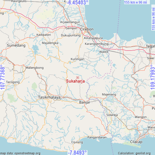
Sukaharja GPS coordinates[2]
7° 9' 7.92" South, 108° 28' 36.48" East
| Map corner | latitude | longitude |
|---|---|---|
| Upper-left | -6.45403°, | 107.77368° |
| Center: | -7.1522°, | 108.4768° |
| Lower-right: | -7.8493°, | 109.17993° |
| Map W x H: | 155.1×155.1 km | = 96.4×96.4mi |
| max Lat: | 5.88969° ⇑42.4% North |
| Sukaharja: | -7.1522° |
| min Lat: | ⇓57.6% South -10.934° |
| min Long | Sukaharja | max Long |
| 95.1345° | 108.4768° | 140.9419° |
| W 28.2%⇐ | ⇒71.8% E |
Elevation
Elevation of Sukaharja is 516 m = 1693 ft, and this is 286.3 m = 939 ft above average elevation for this country.
| Max E: |
3185 m = 10449 ft | 15.1% |
| Sukaharja | 516 m 1693 ft | |
| Avg. | 229.7 m = 754 ft | |
Min E: |
-1 m = -3 ft | 84.9% |
See also: Indonesia elevation on elevation.city.
Geographical zone
Sukaharja is located in South Torrid zone (between Equator and Tropic of Capricorn). Distance of Equator is 795.3 km =494.2 mi to North.| Distance of | km | miles | from Sukaharja |
|---|---|---|---|
| Equator | 795.3 | 494.2 | to North |
| Tropic Capricorn | 1810.7 | 1125.1 | to South |
| Antarctic Circle | 6605.9 | 4104.7 | to South |
| South Pole | 9211.8 | 5723.9 | to South |


Nearby cities:
15 places around Sukaharja: (largest is in red/bold)
• Bantardendang
3.8 km =2.4 mi,  110°
110°
• Ciberung
3.5 km =2.2 mi,  11°
11°
• Citapenpasir
1.6 km =1 mi, 13°
• Curug
3.2 km =2 mi,  56°
56°
• Dadiharja
3.6 km =2.2 mi,  89°
89°
• Janglapa
3.3 km =2.1 mi,  73°
73°
• Kawunglarang
1.6 km =1 mi,  153°
153°
• Kutamangu
4.7 km =2.9 mi,  41°
41°
• Mekarjaya
3.1 km =1.9 mi,  254°
254°
• Pabuaran
4.7 km =2.9 mi, 249°
• Selajambe
4.1 km =2.5 mi,  337°
337°
• Selajambe Satu
4.1 km =2.5 mi,  334°
334°
• Tangkolo
3.8 km =2.4 mi,  101°
101°
• Tanjungjaya
3.9 km =2.4 mi,  224°
224°
• Tigaherang
4.3 km =2.7 mi,  305°
305°
Sources, notices
• [Note1] Compared only with cities in Indonesia existing in our database
• [Src1] Map data: © OpenStreetMap contributors (CC-BY-SA)
• [Src2] Other city data from geonames.org with taken over terms of usage.
• [Src3] Geographical zone / Annual Mean Temperature by Robert A. Rohde @ Wikipedia
