Drajak geodata
Drajak (Central Java) is a seat of a fourth-order administrative division; located in Indonesia in Asia/Jakarta (GMT+7) time zone. In our database, there are 407 cities with bigger population. Compared to other cities in Indonesia, 83.1% of cities are located further ↓South; 64.6% of cities are located further →East and 78.1% of cities have higher elevation than Drajak. Note1


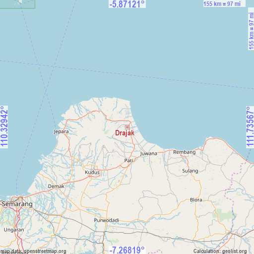
Drajak GPS coordinates[2]
6° 34' 12.684" South, 111° 1' 57.144" East
| Map corner | latitude | longitude |
|---|---|---|
| Upper-left | -5.87121°, | 110.32942° |
| Center: | -6.57019°, | 111.03254° |
| Lower-right: | -7.26819°, | 111.73567° |
| Map W x H: | 155.3×155.3 km | = 96.5×96.5mi |
| max Lat: | 5.88969° ⇑16.9% North |
| Drajak: | -6.57019° |
| min Lat: | ⇓83.1% South -10.934° |
| min Long | Drajak | max Long |
| 95.1345° | 111.03254° | 140.9419° |
| W 35.4%⇐ | ⇒64.6% E |
Elevation
Elevation of Drajak is 21 m = 69 ft, and this is 208.7 m = 685 ft below average elevation for this country.
| Max E: |
3185 m = 10449 ft | 78.1% |
| Avg. | 229.7 m = 754 ft | |
| Drajak | 21 m = 69 ft | |
Min E: |
-1 m = -3 ft | 21.9% |
See also: Indonesia elevation on elevation.city.
Geographical zone
Drajak is located in South Torrid zone (between Equator and Tropic of Capricorn). Distance of Equator is 730.5 km =453.9 mi to North.| Distance of | km | miles | from Drajak |
|---|---|---|---|
| Equator | 730.5 | 453.9 | to North |
| Tropic Capricorn | 1875.4 | 1165.3 | to South |
| Antarctic Circle | 6670.6 | 4144.9 | to South |
| South Pole | 9276.5 | 5764.1 | to South |


Nearby cities:
15 places around Drajak: (largest is in red/bold)
• Bancaran
1.5 km =0.9 mi,  130°
130°
• Belahan
3.1 km =1.9 mi,  92°
92°
• Golong
2.4 km =1.5 mi,  309°
309°
• Jepat Kidul
2.6 km =1.6 mi,  56°
56°
• Kampunganyar
3 km =1.9 mi,  42°
42°
• Kedung
3.4 km =2.1 mi,  158°
158°
• Kedungbang
3.3 km =2.1 mi,  335°
335°
• Ketapang
1.4 km =0.9 mi,  25°
25°
• Krajan Kedungsari
0.9 km =0.6 mi,  113°
113°
• Margotuhu Kidul
3.2 km =2 mi, 105°
• Mrican
2.8 km =1.7 mi, 159°
• Ngetuk
2 km =1.2 mi,  282°
282°
• Rowo
2.5 km =1.6 mi,  18°
18°
• Semerak
2.8 km =1.7 mi, 112°
• Tanggung
1 km =0.6 mi,  69°
69°
Sources, notices
• [Note1] Compared only with cities in Indonesia existing in our database
• [Src1] Map data: © OpenStreetMap contributors (CC-BY-SA)
• [Src2] Other city data from geonames.org with taken over terms of usage.
• [Src3] Geographical zone / Annual Mean Temperature by Robert A. Rohde @ Wikipedia
