Kedung geodata
Kedung (Central Java) is a seat of a fourth-order administrative division; located in Indonesia in Asia/Jakarta (GMT+7) time zone. In our database, there are 407 cities with bigger population. Compared to other cities in Indonesia, 82.6% of cities are located further ↓South; 64.3% of cities are located further →East and 72.7% of cities have higher elevation than Kedung. Note1


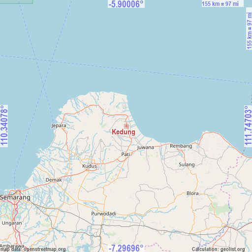
Kedung GPS coordinates[2]
6° 35' 56.4" South, 111° 2' 38.04" East
| Map corner | latitude | longitude |
|---|---|---|
| Upper-left | -5.90006°, | 110.34078° |
| Center: | -6.599°, | 111.0439° |
| Lower-right: | -7.29696°, | 111.74703° |
| Map W x H: | 155.3×155.3 km | = 96.5×96.5mi |
| max Lat: | 5.88969° ⇑17.4% North |
| Kedung: | -6.599° |
| min Lat: | ⇓82.6% South -10.934° |
| min Long | Kedung | max Long |
| 95.1345° | 111.0439° | 140.9419° |
| W 35.7%⇐ | ⇒64.3% E |
Elevation
Elevation of Kedung is 28 m = 92 ft, and this is 201.7 m = 662 ft below average elevation for this country.
| Max E: |
3185 m = 10449 ft | 72.7% |
| Avg. | 229.7 m = 754 ft | |
| Kedung | 28 m = 92 ft | |
Min E: |
-1 m = -3 ft | 27.3% |
See also: Indonesia elevation on elevation.city.
Geographical zone
Kedung is located in South Torrid zone (between Equator and Tropic of Capricorn). Distance of Equator is 733.7 km =455.9 mi to North.| Distance of | km | miles | from Kedung |
|---|---|---|---|
| Equator | 733.7 | 455.9 | to North |
| Tropic Capricorn | 1872.2 | 1163.3 | to South |
| Antarctic Circle | 6667.4 | 4142.9 | to South |
| South Pole | 9273.3 | 5762.2 | to South |


Nearby cities:
15 places around Kedung: (largest is in red/bold)
• Babatan
1.8 km =1.1 mi,  139°
139°
• Bancaran
2.2 km =1.4 mi,  357°
357°
• Bulumanis Lor
2.7 km =1.7 mi,  112°
112°
• Cibolek Kidul
2.4 km =1.5 mi,  95°
95°
• Kajen
1.9 km =1.2 mi,  116°
116°
• Krajan Kedungsari
2.9 km =1.8 mi,  351°
351°
• Krajan Waturoyo
1.5 km =0.9 mi,  72°
72°
• Margotuhu Kidul
3 km =1.9 mi,  38°
38°
• Margoyoso
2.4 km =1.5 mi, 74°
• Mrican
0.7 km =0.4 mi,  334°
334°
• Sekarjalak
2.9 km =1.8 mi, 123°
• Semerak
2.5 km =1.6 mi,  32°
32°
• Sidomukti
3 km =1.9 mi,  161°
161°
• Sumber
2 km =1.2 mi,  218°
218°
• Tunjungrejo
2.5 km =1.6 mi,  83°
83°
Sources, notices
• [Note1] Compared only with cities in Indonesia existing in our database
• [Src1] Map data: © OpenStreetMap contributors (CC-BY-SA)
• [Src2] Other city data from geonames.org with taken over terms of usage.
• [Src3] Geographical zone / Annual Mean Temperature by Robert A. Rohde @ Wikipedia
