Neglasari geodata
Neglasari (West Java) is a seat of a fourth-order administrative division; located in Indonesia in Asia/Jakarta (GMT+7) time zone. In our database, there are 407 cities with bigger population. Compared to other cities in Indonesia, 54.4% of cities are located further ↑North; 71.2% of cities are located further →East and 63.8% of cities have higher elevation than Neglasari. Note1


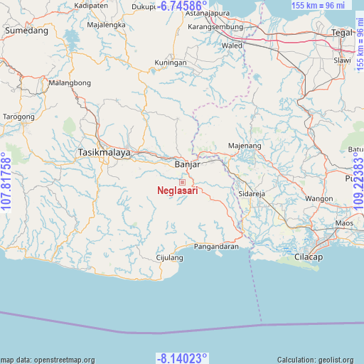
Neglasari GPS coordinates[2]
7° 26' 36.96" South, 108° 31' 14.52" East
| Map corner | latitude | longitude |
|---|---|---|
| Upper-left | -6.74586°, | 107.81758° |
| Center: | -7.4436°, | 108.5207° |
| Lower-right: | -8.14023°, | 109.22383° |
| Map W x H: | 155×155 km | = 96.3×96.3mi |
| max Lat: | 5.88969° ⇑54.4% North |
| Neglasari: | -7.4436° |
| min Lat: | ⇓45.6% South -10.934° |
| min Long | Neglasari | max Long |
| 95.1345° | 108.5207° | 140.9419° |
| W 28.8%⇐ | ⇒71.2% E |
Elevation
Elevation of Neglasari is 46 m = 151 ft, and this is 183.7 m = 603 ft below average elevation for this country.
| Max E: |
3185 m = 10449 ft | 63.8% |
| Avg. | 229.7 m = 754 ft | |
| Neglasari | 46 m = 151 ft | |
Min E: |
-1 m = -3 ft | 36.2% |
See also: Indonesia elevation on elevation.city.
Geographical zone
Neglasari is located in South Torrid zone (between Equator and Tropic of Capricorn). Distance of Equator is 827.7 km =514.3 mi to North.| Distance of | km | miles | from Neglasari |
|---|---|---|---|
| Equator | 827.7 | 514.3 | to North |
| Tropic Capricorn | 1778.3 | 1105 | to South |
| Antarctic Circle | 6573.5 | 4084.6 | to South |
| South Pole | 9179.4 | 5703.8 | to South |


Nearby cities:
15 places around Neglasari: (largest is in red/bold)
• Cilangkap
5 km =3.1 mi,  330°
330°
• Cilisung
3.1 km =1.9 mi,  343°
343°
• Cimanggu
6 km =3.7 mi,  59°
59°
• Cimarga
6.2 km =3.9 mi,  263°
263°
• Ciparay
5.5 km =3.4 mi,  292°
292°
• Hegarsari
6.7 km =4.2 mi,  17°
17°
• Karanganyar
5.6 km =3.5 mi,  184°
184°
• Karangsari
3.9 km =2.4 mi,  80°
80°
• Kertahayu
4.5 km =2.8 mi,  112°
112°
• Neglasari
7 km =4.3 mi,  89°
89°
• Pamarican
1.6 km =1 mi,  166°
166°
• Pangasinan
4.2 km =2.6 mi,  12°
12°
• Sambungjaya
2.7 km =1.7 mi,  139°
139°
• Sukamaju
1.1 km =0.7 mi, 342°
• Warungbuah
6.7 km =4.2 mi, 344°
Sources, notices
• [Note1] Compared only with cities in Indonesia existing in our database
• [Src1] Map data: © OpenStreetMap contributors (CC-BY-SA)
• [Src2] Other city data from geonames.org with taken over terms of usage.
• [Src3] Geographical zone / Annual Mean Temperature by Robert A. Rohde @ Wikipedia
