Cilangkap geodata
Cilangkap (West Java) is a seat of a fourth-order administrative division; located in Indonesia in Asia/Jakarta (GMT+7) time zone. In our database, there are 407 cities with bigger population. Compared to other cities in Indonesia, 53.4% of cities are located further ↑North; 71.5% of cities are located further →East and 61.1% of cities have higher elevation than Cilangkap. Note1


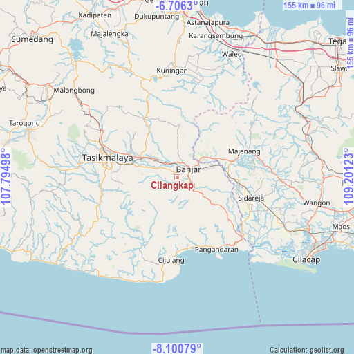
Cilangkap GPS coordinates[2]
7° 24' 14.76" South, 108° 29' 53.16" East
| Map corner | latitude | longitude |
|---|---|---|
| Upper-left | -6.7063°, | 107.79498° |
| Center: | -7.4041°, | 108.4981° |
| Lower-right: | -8.10079°, | 109.20123° |
| Map W x H: | 155.1×155.1 km | = 96.4×96.4mi |
| max Lat: | 5.88969° ⇑53.4% North |
| Cilangkap: | -7.4041° |
| min Lat: | ⇓46.6% South -10.934° |
| min Long | Cilangkap | max Long |
| 95.1345° | 108.4981° | 140.9419° |
| W 28.5%⇐ | ⇒71.5% E |
Elevation
Elevation of Cilangkap is 55 m = 180 ft, and this is 174.7 m = 573 ft below average elevation for this country.
| Max E: |
3185 m = 10449 ft | 61.1% |
| Avg. | 229.7 m = 754 ft | |
| Cilangkap | 55 m = 180 ft | |
Min E: |
-1 m = -3 ft | 38.9% |
See also: Indonesia elevation on elevation.city.
Geographical zone
Cilangkap is located in South Torrid zone (between Equator and Tropic of Capricorn). Distance of Equator is 823.3 km =511.6 mi to North.| Distance of | km | miles | from Cilangkap |
|---|---|---|---|
| Equator | 823.3 | 511.6 | to North |
| Tropic Capricorn | 1782.7 | 1107.7 | to South |
| Antarctic Circle | 6577.9 | 4087.3 | to South |
| South Pole | 9183.8 | 5706.5 | to South |


Nearby cities:
15 places around Cilangkap: (largest is in red/bold)
• Balokang
4.4 km =2.7 mi,  341°
341°
• Banjar
5.5 km =3.4 mi,  44°
44°
• Bojong
2.1 km =1.3 mi,  347°
347°
• Bojongmalang
3.9 km =2.4 mi,  279°
279°
• Cibeureum
3.9 km =2.4 mi,  17°
17°
• Cilisung
2.1 km =1.3 mi,  131°
131°
• Cimaragas
5.3 km =3.3 mi,  312°
312°
• Ciparay
3.5 km =2.2 mi,  228°
228°
• Hegarsari
5 km =3.1 mi,  66°
66°
• Neglasari
5 km =3.1 mi,  150°
150°
• Pangasinan
3.4 km =2.1 mi,  94°
94°
• Raksabaya
5.3 km =3.3 mi,  299°
299°
• Sukamaju
4 km =2.5 mi, 147°
• Sukarame
5.2 km =3.2 mi,  56°
56°
• Warungbuah
2.2 km =1.4 mi, 18°
Sources, notices
• [Note1] Compared only with cities in Indonesia existing in our database
• [Src1] Map data: © OpenStreetMap contributors (CC-BY-SA)
• [Src2] Other city data from geonames.org with taken over terms of usage.
• [Src3] Geographical zone / Annual Mean Temperature by Robert A. Rohde @ Wikipedia
