Tegalharjo geodata
Tegalharjo (Central Java) is a seat of a fourth-order administrative division; located in Indonesia in Asia/Jakarta (GMT+7) time zone. In our database, there are 407 cities with bigger population. Compared to other cities in Indonesia, 82% of cities are located further ↓South; 64.6% of cities are located further →East and 55% of cities have higher elevation than Tegalharjo. Note1


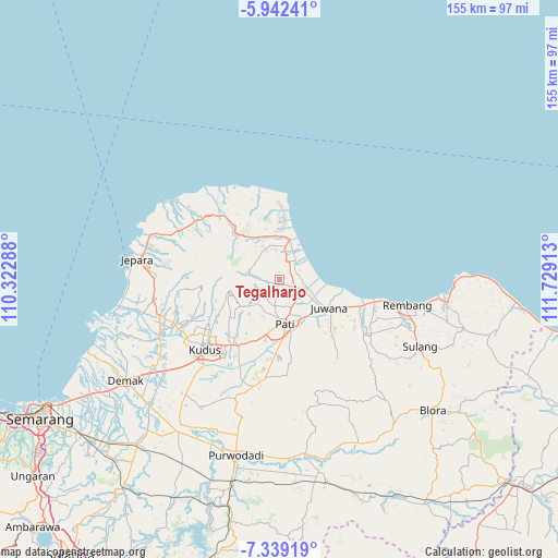
Tegalharjo GPS coordinates[2]
6° 38' 28.68" South, 111° 1' 33.6" East
| Map corner | latitude | longitude |
|---|---|---|
| Upper-left | -5.94241°, | 110.32288° |
| Center: | -6.6413°, | 111.026° |
| Lower-right: | -7.33919°, | 111.72913° |
| Map W x H: | 155.3×155.3 km | = 96.5×96.5mi |
| max Lat: | 5.88969° ⇑18% North |
| Tegalharjo: | -6.6413° |
| min Lat: | ⇓82% South -10.934° |
| min Long | Tegalharjo | max Long |
| 95.1345° | 111.026° | 140.9419° |
| W 35.4%⇐ | ⇒64.6% E |
Elevation
Elevation of Tegalharjo is 85 m = 279 ft, and this is 144.7 m = 475 ft below average elevation for this country.
| Max E: |
3185 m = 10449 ft | 55% |
| Avg. | 229.7 m = 754 ft | |
| Tegalharjo | 85 m = 279 ft | |
Min E: |
-1 m = -3 ft | 45% |
See also: Indonesia elevation on elevation.city.
Geographical zone
Tegalharjo is located in South Torrid zone (between Equator and Tropic of Capricorn). Distance of Equator is 738.4 km =458.8 mi to North.| Distance of | km | miles | from Tegalharjo |
|---|---|---|---|
| Equator | 738.4 | 458.8 | to North |
| Tropic Capricorn | 1867.5 | 1160.4 | to South |
| Antarctic Circle | 6662.7 | 4140 | to South |
| South Pole | 9268.6 | 5759.2 | to South |


Nearby cities:
15 places around Tegalharjo: (largest is in red/bold)
• Babatan
4.6 km =2.9 mi,  42°
42°
• Bagangan
2 km =1.2 mi,  184°
184°
• Bantengan
4.6 km =2.9 mi,  116°
116°
• Cabak Satu
4 km =2.5 mi,  296°
296°
• Ketanen
4.4 km =2.7 mi,  108°
108°
• Krajan Tanjungrejo
2.2 km =1.4 mi,  67°
67°
• Lahar
3.6 km =2.2 mi,  263°
263°
• Pasucen
3.4 km =2.1 mi, 122°
• Pesagen
4.5 km =2.8 mi,  341°
341°
• Pohbango
4 km =2.5 mi,  91°
91°
• Sanglur
3.5 km =2.2 mi,  227°
227°
• Sidomukti
3.5 km =2.2 mi,  57°
57°
• Sumber
3.2 km =2 mi,  12°
12°
• Suwatu
2.3 km =1.4 mi, 299°
• Tegalarum
3.8 km =2.4 mi,  334°
334°
Sources, notices
• [Note1] Compared only with cities in Indonesia existing in our database
• [Src1] Map data: © OpenStreetMap contributors (CC-BY-SA)
• [Src2] Other city data from geonames.org with taken over terms of usage.
• [Src3] Geographical zone / Annual Mean Temperature by Robert A. Rohde @ Wikipedia
