Tapen geodata
Tapen (Central Java) is a seat of a fourth-order administrative division; located in Indonesia in Asia/Jakarta (GMT+7) time zone. In our database, there are 407 cities with bigger population. Compared to other cities in Indonesia, 82.1% of cities are located further ↓South; 63.7% of cities are located further →East and 92.1% of cities have higher elevation than Tapen. Note1


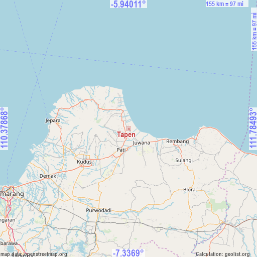
Tapen GPS coordinates[2]
6° 38' 20.4" South, 111° 4' 54.48" East
| Map corner | latitude | longitude |
|---|---|---|
| Upper-left | -5.94011°, | 110.37868° |
| Center: | -6.639°, | 111.0818° |
| Lower-right: | -7.3369°, | 111.78493° |
| Map W x H: | 155.3×155.3 km | = 96.5×96.5mi |
| max Lat: | 5.88969° ⇑17.9% North |
| Tapen: | -6.639° |
| min Lat: | ⇓82.1% South -10.934° |
| min Long | Tapen | max Long |
| 95.1345° | 111.0818° | 140.9419° |
| W 36.3%⇐ | ⇒63.7% E |
Elevation
Elevation of Tapen is 9 m = 30 ft, and this is 220.7 m = 724 ft below average elevation for this country.
| Max E: |
3185 m = 10449 ft | 92.1% |
| Avg. | 229.7 m = 754 ft | |
| Tapen | 9 m = 30 ft | |
Min E: |
-1 m = -3 ft | 7.9% |
See also: Indonesia elevation on elevation.city.
Geographical zone
Tapen is located in South Torrid zone (between Equator and Tropic of Capricorn). Distance of Equator is 738.2 km =458.7 mi to North.| Distance of | km | miles | from Tapen |
|---|---|---|---|
| Equator | 738.2 | 458.7 | to North |
| Tropic Capricorn | 1867.7 | 1160.5 | to South |
| Antarctic Circle | 6663 | 4140.2 | to South |
| South Pole | 9268.9 | 5759.4 | to South |


Nearby cities:
15 places around Tapen: (largest is in red/bold)
• Bantengan
3.1 km =1.9 mi,  221°
221°
• Bonagung
2.5 km =1.6 mi,  162°
162°
• Geneng
2.4 km =1.5 mi,  135°
135°
• Guyangan
3 km =1.9 mi, 140°
• Kadilangu
1 km =0.6 mi,  149°
149°
• Ketanen
2.6 km =1.6 mi,  230°
230°
• Krajan Karangwage
1.3 km =0.8 mi,  247°
247°
• Krajan Langenharjo
1.1 km =0.7 mi,  18°
18°
• Krandan
1.4 km =0.9 mi,  174°
174°
• Pangkalan
2.3 km =1.4 mi,  350°
350°
• Pohbango
2.2 km =1.4 mi,  259°
259°
• Pohijo
1.8 km =1.1 mi,  321°
321°
• Rejoso
2.5 km =1.6 mi,  210°
210°
• Tlutup
1.4 km =0.9 mi, 145°
• Trangkil
2.8 km =1.7 mi,  196°
196°
Sources, notices
• [Note1] Compared only with cities in Indonesia existing in our database
• [Src1] Map data: © OpenStreetMap contributors (CC-BY-SA)
• [Src2] Other city data from geonames.org with taken over terms of usage.
• [Src3] Geographical zone / Annual Mean Temperature by Robert A. Rohde @ Wikipedia
