Ngulaan geodata
Ngulaan (Central Java) is a seat of a fourth-order administrative division; located in Indonesia in Asia/Jakarta (GMT+7) time zone. In our database, there are 407 cities with bigger population. Compared to other cities in Indonesia, 80.6% of cities are located further ↓South; 63.9% of cities are located further →East and 80.9% of cities have higher elevation than Ngulaan. Note1


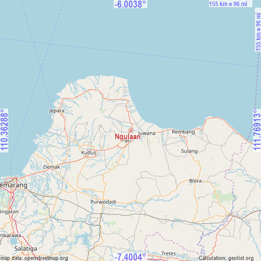
Ngulaan GPS coordinates[2]
6° 42' 9.36" South, 111° 3' 57.6" East
| Map corner | latitude | longitude |
|---|---|---|
| Upper-left | -6.0038°, | 110.36288° |
| Center: | -6.7026°, | 111.066° |
| Lower-right: | -7.4004°, | 111.76913° |
| Map W x H: | 155.3×155.3 km | = 96.5×96.5mi |
| max Lat: | 5.88969° ⇑19.4% North |
| Ngulaan: | -6.7026° |
| min Lat: | ⇓80.6% South -10.934° |
| min Long | Ngulaan | max Long |
| 95.1345° | 111.066° | 140.9419° |
| W 36.1%⇐ | ⇒63.9% E |
Elevation
Elevation of Ngulaan is 18 m = 59 ft, and this is 211.7 m = 695 ft below average elevation for this country.
| Max E: |
3185 m = 10449 ft | 80.9% |
| Avg. | 229.7 m = 754 ft | |
| Ngulaan | 18 m = 59 ft | |
Min E: |
-1 m = -3 ft | 19.1% |
See also: Indonesia elevation on elevation.city.
Geographical zone
Ngulaan is located in South Torrid zone (between Equator and Tropic of Capricorn). Distance of Equator is 745.3 km =463.1 mi to North.| Distance of | km | miles | from Ngulaan |
|---|---|---|---|
| Equator | 745.3 | 463.1 | to North |
| Tropic Capricorn | 1860.7 | 1156.2 | to South |
| Antarctic Circle | 6655.9 | 4135.8 | to South |
| South Pole | 9261.8 | 5755 | to South |


Nearby cities:
15 places around Ngulaan: (largest is in red/bold)
• Bapoh
1.4 km =0.9 mi,  234°
234°
• Jontro
1.3 km =0.8 mi,  24°
24°
• Karanganyar
2 km =1.2 mi,  104°
104°
• Kebonagung
1 km =0.6 mi,  175°
175°
• Koroyo
1.5 km =0.9 mi,  3°
3°
• Ngaliyan
2.5 km =1.6 mi,  266°
266°
• Ngepungkrajan
2.1 km =1.3 mi,  162°
162°
• Ngurenrejo
1.9 km =1.2 mi,  67°
67°
• Ngurensiti
2.3 km =1.4 mi,  79°
79°
• Pagerharjo
3.4 km =2.1 mi,  39°
39°
• Payang
2.9 km =1.8 mi,  193°
193°
• Runting
2.6 km =1.6 mi,  213°
213°
• Suwaduk
2.5 km =1.6 mi,  345°
345°
• Tambakromo
2.6 km =1.6 mi, 175°
• Wedarijaksa
2.4 km =1.5 mi,  14°
14°
Sources, notices
• [Note1] Compared only with cities in Indonesia existing in our database
• [Src1] Map data: © OpenStreetMap contributors (CC-BY-SA)
• [Src2] Other city data from geonames.org with taken over terms of usage.
• [Src3] Geographical zone / Annual Mean Temperature by Robert A. Rohde @ Wikipedia
