Cigalumpit geodata
Cigalumpit (Central Java) is a seat of a fourth-order administrative division; located in Indonesia in Asia/Jakarta (GMT+7) time zone. In our database, there are 407 cities with bigger population. Compared to other cities in Indonesia, 51.1% of cities are located further ↓South; 70.1% of cities are located further →East and 57.4% of cities have higher elevation than Cigalumpit. Note1


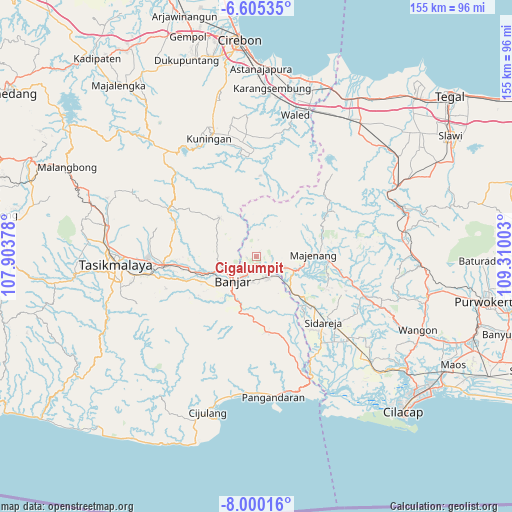
Cigalumpit GPS coordinates[2]
7° 18' 11.88" South, 108° 36' 24.84" East
| Map corner | latitude | longitude |
|---|---|---|
| Upper-left | -6.60535°, | 107.90378° |
| Center: | -7.3033°, | 108.6069° |
| Lower-right: | -8.00016°, | 109.31003° |
| Map W x H: | 155.1×155.1 km | = 96.4×96.4mi |
| max Lat: | 5.88969° ⇑48.9% North |
| Cigalumpit: | -7.3033° |
| min Lat: | ⇓51.1% South -10.934° |
| min Long | Cigalumpit | max Long |
| 95.1345° | 108.6069° | 140.9419° |
| W 29.9%⇐ | ⇒70.1% E |
Elevation
Elevation of Cigalumpit is 70 m = 230 ft, and this is 159.7 m = 524 ft below average elevation for this country.
| Max E: |
3185 m = 10449 ft | 57.4% |
| Avg. | 229.7 m = 754 ft | |
| Cigalumpit | 70 m = 230 ft | |
Min E: |
-1 m = -3 ft | 42.6% |
See also: Indonesia elevation on elevation.city.
Geographical zone
Cigalumpit is located in South Torrid zone (between Equator and Tropic of Capricorn). Distance of Equator is 812.1 km =504.6 mi to North.| Distance of | km | miles | from Cigalumpit |
|---|---|---|---|
| Equator | 812.1 | 504.6 | to North |
| Tropic Capricorn | 1793.9 | 1114.7 | to South |
| Antarctic Circle | 6589.1 | 4094.3 | to South |
| South Pole | 9195 | 5713.5 | to South |


Nearby cities:
15 places around Cigalumpit: (largest is in red/bold)
• Bangunharja
6.3 km =3.9 mi,  280°
280°
• Batububut
3.6 km =2.2 mi,  267°
267°
• Cimalati
4.4 km =2.7 mi,  93°
93°
• Cirateun
3.3 km =2.1 mi,  333°
333°
• Ciwalen
2.6 km =1.6 mi,  2°
2°
• Dayeuhluhur
4.9 km =3 mi,  5°
5°
• Karanganyar
5.2 km =3.2 mi,  126°
126°
• Kubang
4.8 km =3 mi,  46°
46°
• Margamulya
6.6 km =4.1 mi,  306°
306°
• Panulisan
3.1 km =1.9 mi,  260°
260°
• Randegan
6.7 km =4.2 mi,  215°
215°
• Randegan Dua
7.2 km =4.5 mi, 216°
• Sinargalih
6.9 km =4.3 mi,  150°
150°
• Sindanggalih
6.7 km =4.2 mi,  163°
163°
• Sukahurip
6.3 km =3.9 mi, 149°
Sources, notices
• [Note1] Compared only with cities in Indonesia existing in our database
• [Src1] Map data: © OpenStreetMap contributors (CC-BY-SA)
• [Src2] Other city data from geonames.org with taken over terms of usage.
• [Src3] Geographical zone / Annual Mean Temperature by Robert A. Rohde @ Wikipedia
