Pandean geodata
Pandean (Central Java) is a seat of a fourth-order administrative division; located in Indonesia in Asia/Jakarta (GMT+7) time zone. In our database, there are 407 cities with bigger population. Compared to other cities in Indonesia, 80.5% of cities are located further ↓South; 61% of cities are located further →East and 95.5% of cities have higher elevation than Pandean. Note1


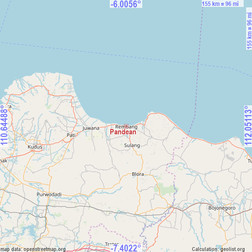
Pandean GPS coordinates[2]
6° 42' 15.84" South, 111° 20' 52.8" East
| Map corner | latitude | longitude |
|---|---|---|
| Upper-left | -6.0056°, | 110.64488° |
| Center: | -6.7044°, | 111.348° |
| Lower-right: | -7.4022°, | 112.05113° |
| Map W x H: | 155.3×155.3 km | = 96.5×96.5mi |
| max Lat: | 5.88969° ⇑19.5% North |
| Pandean: | -6.7044° |
| min Lat: | ⇓80.5% South -10.934° |
| min Long | Pandean | max Long |
| 95.1345° | 111.348° | 140.9419° |
| W 39%⇐ | ⇒61% E |
Elevation
Elevation of Pandean is 7 m = 23 ft, and this is 222.7 m = 731 ft below average elevation for this country.
| Max E: |
3185 m = 10449 ft | 95.5% |
| Avg. | 229.7 m = 754 ft | |
| Pandean | 7 m = 23 ft | |
Min E: |
-1 m = -3 ft | 4.5% |
See also: Indonesia elevation on elevation.city.
Geographical zone
Pandean is located in South Torrid zone (between Equator and Tropic of Capricorn). Distance of Equator is 745.5 km =463.2 mi to North.| Distance of | km | miles | from Pandean |
|---|---|---|---|
| Equator | 745.5 | 463.2 | to North |
| Tropic Capricorn | 1860.5 | 1156.1 | to South |
| Antarctic Circle | 6655.7 | 4135.7 | to South |
| South Pole | 9261.6 | 5754.9 | to South |


Nearby cities:
15 places around Pandean: (largest is in red/bold)
• Kabongan Kidul
1.2 km =0.7 mi,  110°
110°
• Kabongan Lor
1 km =0.6 mi,  95°
95°
• Karanggeneng
2 km =1.2 mi,  276°
276°
• Kasingan
0.5 km =0.3 mi,  123°
123°
• Kedungdoro
1.5 km =0.9 mi,  188°
188°
• Kutoharjo
0.4 km =0.2 mi,  248°
248°
• Magersari
2.5 km =1.6 mi,  274°
274°
• Pabean
1.6 km =1 mi, 277°
• Rembang
0.4 km =0.2 mi,  145°
145°
• Rembangan
0.7 km =0.4 mi, 277°
• Sawahan
1.1 km =0.7 mi,  244°
244°
• Sidowayah Kidul
1.8 km =1.1 mi,  183°
183°
• Sidowayah Lor
0.7 km =0.4 mi,  168°
168°
• Sumberejo
1.2 km =0.7 mi,  228°
228°
• Tireman Timur
2.6 km =1.6 mi,  93°
93°
Sources, notices
• [Note1] Compared only with cities in Indonesia existing in our database
• [Src1] Map data: © OpenStreetMap contributors (CC-BY-SA)
• [Src2] Other city data from geonames.org with taken over terms of usage.
• [Src3] Geographical zone / Annual Mean Temperature by Robert A. Rohde @ Wikipedia
