Kedungdoro geodata
Kedungdoro (Central Java) is a seat of a fourth-order administrative division; located in Indonesia in Asia/Jakarta (GMT+7) time zone. In our database, there are 407 cities with bigger population. Compared to other cities in Indonesia, 79.8% of cities are located further ↓South; 61.1% of cities are located further →East and 79.9% of cities have higher elevation than Kedungdoro. Note1


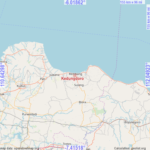
Kedungdoro GPS coordinates[2]
6° 43' 2.64" South, 111° 20' 45.96" East
| Map corner | latitude | longitude |
|---|---|---|
| Upper-left | -6.01862°, | 110.64298° |
| Center: | -6.7174°, | 111.3461° |
| Lower-right: | -7.41518°, | 112.04923° |
| Map W x H: | 155.3×155.3 km | = 96.5×96.5mi |
| max Lat: | 5.88969° ⇑20.2% North |
| Kedungdoro: | -6.7174° |
| min Lat: | ⇓79.8% South -10.934° |
| min Long | Kedungdoro | max Long |
| 95.1345° | 111.3461° | 140.9419° |
| W 38.9%⇐ | ⇒61.1% E |
Elevation
Elevation of Kedungdoro is 19 m = 62 ft, and this is 210.7 m = 691 ft below average elevation for this country.
| Max E: |
3185 m = 10449 ft | 79.9% |
| Avg. | 229.7 m = 754 ft | |
| Kedungdoro | 19 m = 62 ft | |
Min E: |
-1 m = -3 ft | 20.1% |
See also: Indonesia elevation on elevation.city.
Geographical zone
Kedungdoro is located in South Torrid zone (between Equator and Tropic of Capricorn). Distance of Equator is 746.9 km =464.1 mi to North.| Distance of | km | miles | from Kedungdoro |
|---|---|---|---|
| Equator | 746.9 | 464.1 | to North |
| Tropic Capricorn | 1859 | 1155.1 | to South |
| Antarctic Circle | 6654.3 | 4134.8 | to South |
| South Pole | 9260.2 | 5754 | to South |


Nearby cities:
15 places around Kedungdoro: (largest is in red/bold)
• Kabongan Kidul
1.7 km =1.1 mi,  51°
51°
• Kabongan Lor
1.8 km =1.1 mi,  41°
41°
• Kasingan
1.3 km =0.8 mi,  29°
29°
• Ketanggi
1.7 km =1.1 mi,  204°
204°
• Kutoharjo
1.3 km =0.8 mi,  354°
354°
• Mondoteko
2.1 km =1.3 mi,  183°
183°
• Ngotet Kidul
2 km =1.2 mi,  138°
138°
• Pandean
1.5 km =0.9 mi,  8°
8°
• Pulo
2 km =1.2 mi,  237°
237°
• Rembang
1.2 km =0.7 mi,  19°
19°
• Rembangan
1.6 km =1 mi,  342°
342°
• Sawahan
1.2 km =0.7 mi,  322°
322°
• Sidowayah Kidul
0.3 km =0.2 mi,  162°
162°
• Sidowayah Lor
0.8 km =0.5 mi, 25°
• Sumberejo
0.9 km =0.6 mi,  313°
313°
Sources, notices
• [Note1] Compared only with cities in Indonesia existing in our database
• [Src1] Map data: © OpenStreetMap contributors (CC-BY-SA)
• [Src2] Other city data from geonames.org with taken over terms of usage.
• [Src3] Geographical zone / Annual Mean Temperature by Robert A. Rohde @ Wikipedia
