Ngargomulyo geodata
Ngargomulyo (Central Java) is a seat of a fourth-order administrative division; located in Indonesia in Asia/Jakarta (GMT+7) time zone. In our database, there are 407 cities with bigger population. Compared to other cities in Indonesia, 81.1% of cities are located further ↓South; 58.1% of cities are located further →East and 68.9% of cities have lower elevation than Ngargomulyo. Note1


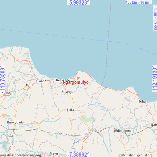
Ngargomulyo GPS coordinates[2]
6° 41' 31.56" South, 111° 29' 17.52" East
| Map corner | latitude | longitude |
|---|---|---|
| Upper-left | -5.99328°, | 110.78508° |
| Center: | -6.6921°, | 111.4882° |
| Lower-right: | -7.38992°, | 112.19133° |
| Map W x H: | 155.3×155.3 km | = 96.5×96.5mi |
| max Lat: | 5.88969° ⇑18.9% North |
| Ngargomulyo: | -6.6921° |
| min Lat: | ⇓81.1% South -10.934° |
| min Long | Ngargomulyo | max Long |
| 95.1345° | 111.4882° | 140.9419° |
| W 41.9%⇐ | ⇒58.1% E |
Elevation
Elevation of Ngargomulyo is 278 m = 912 ft, and this is 48.3 m = 158 ft above average elevation for this country.
| Max E: |
3185 m = 10449 ft | 31.1% |
| Ngargomulyo | 278 m 912 ft | |
| Avg. | 229.7 m = 754 ft | |
Min E: |
-1 m = -3 ft | 68.9% |
See also: Indonesia elevation on elevation.city.
Geographical zone
Ngargomulyo is located in South Torrid zone (between Equator and Tropic of Capricorn). Distance of Equator is 744.1 km =462.4 mi to North.| Distance of | km | miles | from Ngargomulyo |
|---|---|---|---|
| Equator | 744.1 | 462.4 | to North |
| Tropic Capricorn | 1861.8 | 1156.9 | to South |
| Antarctic Circle | 6657.1 | 4136.5 | to South |
| South Pole | 9263 | 5755.8 | to South |


Nearby cities:
15 places around Ngargomulyo: (largest is in red/bold)
• Banyuurip
2.3 km =1.4 mi,  153°
153°
• Bendan
3.2 km =2 mi,  287°
287°
• Criwik
1.8 km =1.1 mi, 154°
• Johogunung
3.2 km =2 mi, 150°
• Kajar
1.3 km =0.8 mi,  275°
275°
• Kalilu
1.1 km =0.7 mi,  357°
357°
• Karangrejo
3.9 km =2.4 mi,  272°
272°
• Krajan Wuwur
3.3 km =2.1 mi,  190°
190°
• Lasem
3.9 km =2.4 mi, 269°
• Logading
3.1 km =1.9 mi,  329°
329°
• Mentoro Wetan
0.8 km =0.5 mi,  163°
163°
• Ngandangan
2.7 km =1.7 mi,  263°
263°
• Ngulangan
2.9 km =1.8 mi,  182°
182°
• Pancur
3.9 km =2.4 mi,  213°
213°
• Warugunung
3.9 km =2.4 mi,  243°
243°
Sources, notices
• [Note1] Compared only with cities in Indonesia existing in our database
• [Src1] Map data: © OpenStreetMap contributors (CC-BY-SA)
• [Src2] Other city data from geonames.org with taken over terms of usage.
• [Src3] Geographical zone / Annual Mean Temperature by Robert A. Rohde @ Wikipedia
