Gandik geodata
Gandik (Central Java) is a seat of a fourth-order administrative division; located in Indonesia in Asia/Jakarta (GMT+7) time zone. In our database, there are 407 cities with bigger population. Compared to other cities in Indonesia, 79.6% of cities are located further ↓South; 60.7% of cities are located further →East and 81.9% of cities have higher elevation than Gandik. Note1


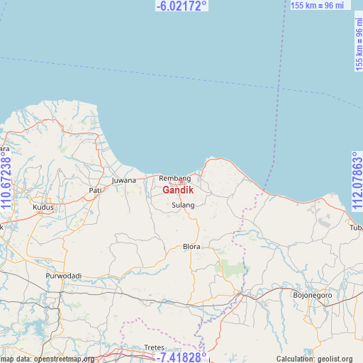
Gandik GPS coordinates[2]
6° 43' 13.8" South, 111° 22' 31.8" East
| Map corner | latitude | longitude |
|---|---|---|
| Upper-left | -6.02172°, | 110.67238° |
| Center: | -6.7205°, | 111.3755° |
| Lower-right: | -7.41828°, | 112.07863° |
| Map W x H: | 155.3×155.3 km | = 96.5×96.5mi |
| max Lat: | 5.88969° ⇑20.4% North |
| Gandik: | -6.7205° |
| min Lat: | ⇓79.6% South -10.934° |
| min Long | Gandik | max Long |
| 95.1345° | 111.3755° | 140.9419° |
| W 39.3%⇐ | ⇒60.7% E |
Elevation
Elevation of Gandik is 17 m = 56 ft, and this is 212.7 m = 698 ft below average elevation for this country.
| Max E: |
3185 m = 10449 ft | 81.9% |
| Avg. | 229.7 m = 754 ft | |
| Gandik | 17 m = 56 ft | |
Min E: |
-1 m = -3 ft | 18.1% |
See also: Indonesia elevation on elevation.city.
Geographical zone
Gandik is located in South Torrid zone (between Equator and Tropic of Capricorn). Distance of Equator is 747.2 km =464.3 mi to North.| Distance of | km | miles | from Gandik |
|---|---|---|---|
| Equator | 747.2 | 464.3 | to North |
| Tropic Capricorn | 1858.7 | 1154.9 | to South |
| Antarctic Circle | 6653.9 | 4134.5 | to South |
| South Pole | 9259.8 | 5753.8 | to South |


Nearby cities:
15 places around Gandik: (largest is in red/bold)
• Balong Kulon
1.6 km =1 mi,  169°
169°
• Garang
3.1 km =1.9 mi,  95°
95°
• Kabongan Kidul
2.4 km =1.5 mi,  305°
305°
• Kabongan Lor
2.7 km =1.7 mi, 309°
• Kasingan
3 km =1.9 mi,  300°
300°
• Lojigawaran
3 km =1.9 mi,  217°
217°
• Ngangpo
1.8 km =1.1 mi,  129°
129°
• Ngotet Kidul
2.2 km =1.4 mi,  238°
238°
• Nrondo
2.3 km =1.4 mi,  201°
201°
• Padaran
2.8 km =1.7 mi,  93°
93°
• Pasarbanggi
3.2 km =2 mi,  40°
40°
• Sidowayah Kidul
3.1 km =1.9 mi,  270°
270°
• Sidowayah Lor
3.1 km =1.9 mi,  290°
290°
• Tireman Timur
1.7 km =1.1 mi,  345°
345°
• Weton
1.5 km =0.9 mi, 204°
Sources, notices
• [Note1] Compared only with cities in Indonesia existing in our database
• [Src1] Map data: © OpenStreetMap contributors (CC-BY-SA)
• [Src2] Other city data from geonames.org with taken over terms of usage.
• [Src3] Geographical zone / Annual Mean Temperature by Robert A. Rohde @ Wikipedia
