Nrondo geodata
Nrondo (Central Java) is a seat of a fourth-order administrative division; located in Indonesia in Asia/Jakarta (GMT+7) time zone. In our database, there are 407 cities with bigger population. Compared to other cities in Indonesia, 78.7% of cities are located further ↓South; 60.8% of cities are located further →East and 68% of cities have higher elevation than Nrondo. Note1


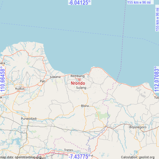
Nrondo GPS coordinates[2]
6° 44' 24" South, 111° 22' 3.72" East
| Map corner | latitude | longitude |
|---|---|---|
| Upper-left | -6.04125°, | 110.66458° |
| Center: | -6.74°, | 111.3677° |
| Lower-right: | -7.43775°, | 112.07083° |
| Map W x H: | 155.3×155.3 km | = 96.5×96.5mi |
| max Lat: | 5.88969° ⇑21.3% North |
| Nrondo: | -6.74° |
| min Lat: | ⇓78.7% South -10.934° |
| min Long | Nrondo | max Long |
| 95.1345° | 111.3677° | 140.9419° |
| W 39.2%⇐ | ⇒60.8% E |
Elevation
Elevation of Nrondo is 36 m = 118 ft, and this is 193.7 m = 635 ft below average elevation for this country.
| Max E: |
3185 m = 10449 ft | 68% |
| Avg. | 229.7 m = 754 ft | |
| Nrondo | 36 m = 118 ft | |
Min E: |
-1 m = -3 ft | 32% |
See also: Indonesia elevation on elevation.city.
Geographical zone
Nrondo is located in South Torrid zone (between Equator and Tropic of Capricorn). Distance of Equator is 749.4 km =465.7 mi to North.| Distance of | km | miles | from Nrondo |
|---|---|---|---|
| Equator | 749.4 | 465.7 | to North |
| Tropic Capricorn | 1856.5 | 1153.6 | to South |
| Antarctic Circle | 6651.8 | 4133.2 | to South |
| South Pole | 9257.6 | 5752.4 | to South |


Nearby cities:
15 places around Nrondo: (largest is in red/bold)
• Balong Kulon
1.3 km =0.8 mi,  64°
64°
• Bogorame
3.1 km =1.9 mi,  202°
202°
• Gandik
2.3 km =1.4 mi,  21°
21°
• Kebon
2.1 km =1.3 mi,  238°
238°
• Kebonagung
2.9 km =1.8 mi, 241°
• Kerep Wetan
3.1 km =1.9 mi,  125°
125°
• Ketanggi
3.2 km =2 mi,  286°
286°
• Krajan Landoh
2.6 km =1.6 mi,  172°
172°
• Lojigawaran
1 km =0.6 mi,  256°
256°
• Mondoteko
2.5 km =1.6 mi,  280°
280°
• Ngangpo
2.5 km =1.6 mi,  65°
65°
• Ngotet Kidul
1.5 km =0.9 mi,  313°
313°
• Pranti
2.7 km =1.7 mi,  210°
210°
• Sidowayah Kidul
3.2 km =2 mi, 313°
• Weton
0.8 km =0.5 mi, 16°
Sources, notices
• [Note1] Compared only with cities in Indonesia existing in our database
• [Src1] Map data: © OpenStreetMap contributors (CC-BY-SA)
• [Src2] Other city data from geonames.org with taken over terms of usage.
• [Src3] Geographical zone / Annual Mean Temperature by Robert A. Rohde @ Wikipedia
