Ngroto geodata
Ngroto (Central Java) is a seat of a fourth-order administrative division; located in Indonesia in Asia/Jakarta (GMT+7) time zone. In our database, there are 407 cities with bigger population. Compared to other cities in Indonesia, 79.9% of cities are located further ↓South; 57.5% of cities are located further →East and 70.9% of cities have lower elevation than Ngroto. Note1


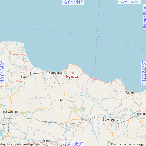
Ngroto GPS coordinates[2]
6° 42' 46.44" South, 111° 31' 10.56" East
| Map corner | latitude | longitude |
|---|---|---|
| Upper-left | -6.01411°, | 110.81648° |
| Center: | -6.7129°, | 111.5196° |
| Lower-right: | -7.41069°, | 112.22273° |
| Map W x H: | 155.3×155.3 km | = 96.5×96.5mi |
| max Lat: | 5.88969° ⇑20.1% North |
| Ngroto: | -6.7129° |
| min Lat: | ⇓79.9% South -10.934° |
| min Long | Ngroto | max Long |
| 95.1345° | 111.5196° | 140.9419° |
| W 42.5%⇐ | ⇒57.5% E |
Elevation
Elevation of Ngroto is 305 m = 1001 ft, and this is 75.3 m = 247 ft above average elevation for this country.
| Max E: |
3185 m = 10449 ft | 29.1% |
| Ngroto | 305 m 1001 ft | |
| Avg. | 229.7 m = 754 ft | |
Min E: |
-1 m = -3 ft | 70.9% |
See also: Indonesia elevation on elevation.city.
Geographical zone
Ngroto is located in South Torrid zone (between Equator and Tropic of Capricorn). Distance of Equator is 746.4 km =463.8 mi to North.| Distance of | km | miles | from Ngroto |
|---|---|---|---|
| Equator | 746.4 | 463.8 | to North |
| Tropic Capricorn | 1859.5 | 1155.4 | to South |
| Antarctic Circle | 6654.8 | 4135.1 | to South |
| South Pole | 9260.7 | 5754.3 | to South |


Nearby cities:
15 places around Ngroto: (largest is in red/bold)
• Banyuurip
2.4 km =1.5 mi,  275°
275°
• Carian
1.2 km =0.7 mi,  150°
150°
• Criwik
2.8 km =1.7 mi,  285°
285°
• Dadapan
2.2 km =1.4 mi,  80°
80°
• Dukuan
3.6 km =2.2 mi,  48°
48°
• Gerdu
1.6 km =1 mi,  165°
165°
• Johogunung
2 km =1.2 mi,  254°
254°
• Kedung
3.4 km =2.1 mi,  237°
237°
• Mentoro Wetan
3.6 km =2.2 mi,  295°
295°
• Ngulangan
3.6 km =2.2 mi,  261°
261°
• Sambong
3.3 km =2.1 mi,  112°
112°
• Sambongmulyo
3.8 km =2.4 mi,  229°
229°
• Sidowayah
3.2 km =2 mi,  216°
216°
• Tanjungsari
3.8 km =2.4 mi, 81°
• Trenggulunan
1 km =0.6 mi,  213°
213°
Sources, notices
• [Note1] Compared only with cities in Indonesia existing in our database
• [Src1] Map data: © OpenStreetMap contributors (CC-BY-SA)
• [Src2] Other city data from geonames.org with taken over terms of usage.
• [Src3] Geographical zone / Annual Mean Temperature by Robert A. Rohde @ Wikipedia
