Jambeyan geodata
Jambeyan (Central Java) is a seat of a fourth-order administrative division; located in Indonesia in Asia/Jakarta (GMT+7) time zone. In our database, there are 407 cities with bigger population. Compared to other cities in Indonesia, 79.2% of cities are located further ↓South; 56.6% of cities are located further →East and 74.1% of cities have higher elevation than Jambeyan. Note1


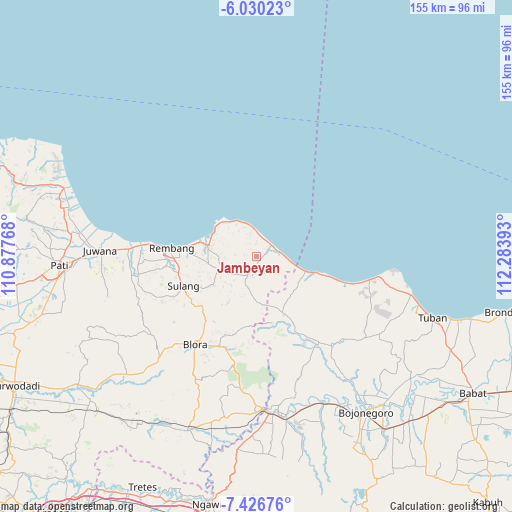
Jambeyan GPS coordinates[2]
6° 43' 44.4" South, 111° 34' 50.88" East
| Map corner | latitude | longitude |
|---|---|---|
| Upper-left | -6.03023°, | 110.87768° |
| Center: | -6.729°, | 111.5808° |
| Lower-right: | -7.42676°, | 112.28393° |
| Map W x H: | 155.3×155.3 km | = 96.5×96.5mi |
| max Lat: | 5.88969° ⇑20.8% North |
| Jambeyan: | -6.729° |
| min Lat: | ⇓79.2% South -10.934° |
| min Long | Jambeyan | max Long |
| 95.1345° | 111.5808° | 140.9419° |
| W 43.4%⇐ | ⇒56.6% E |
Elevation
Elevation of Jambeyan is 26 m = 85 ft, and this is 203.7 m = 668 ft below average elevation for this country.
| Max E: |
3185 m = 10449 ft | 74.1% |
| Avg. | 229.7 m = 754 ft | |
| Jambeyan | 26 m = 85 ft | |
Min E: |
-1 m = -3 ft | 25.9% |
See also: Indonesia elevation on elevation.city.
Geographical zone
Jambeyan is located in South Torrid zone (between Equator and Tropic of Capricorn). Distance of Equator is 748.2 km =464.9 mi to North.| Distance of | km | miles | from Jambeyan |
|---|---|---|---|
| Equator | 748.2 | 464.9 | to North |
| Tropic Capricorn | 1857.7 | 1154.3 | to South |
| Antarctic Circle | 6653 | 4134 | to South |
| South Pole | 9258.9 | 5753.2 | to South |


Nearby cities:
15 places around Jambeyan: (largest is in red/bold)
• Bogorejo
2.3 km =1.4 mi,  271°
271°
• Gobreh
3.4 km =2.1 mi,  153°
153°
• Juwen
2.7 km =1.7 mi,  322°
322°
• Karangasem
3 km =1.9 mi,  176°
176°
• Kedungringin
1.1 km =0.7 mi,  160°
160°
• Kendalagung
3.4 km =2.1 mi,  49°
49°
• Krajan Gandrirejo
1.6 km =1 mi, 269°
• Krajanpondong
3.3 km =2.1 mi,  214°
214°
• Menara
1.2 km =0.7 mi,  86°
86°
• Mojokerto
3.1 km =1.9 mi,  98°
98°
• Ngasinan
1.7 km =1.1 mi,  21°
21°
• Sambong
3.7 km =2.3 mi,  278°
278°
• Sendangwaru
2.5 km =1.6 mi,  343°
343°
• Sudan
3.6 km =2.2 mi,  356°
356°
• Sulo
0.9 km =0.6 mi,  258°
258°
Sources, notices
• [Note1] Compared only with cities in Indonesia existing in our database
• [Src1] Map data: © OpenStreetMap contributors (CC-BY-SA)
• [Src2] Other city data from geonames.org with taken over terms of usage.
• [Src3] Geographical zone / Annual Mean Temperature by Robert A. Rohde @ Wikipedia
