Kedungringin geodata
Kedungringin (Central Java) is a seat of a fourth-order administrative division; located in Indonesia in Asia/Jakarta (GMT+7) time zone. In our database, there are 407 cities with bigger population. Compared to other cities in Indonesia, 78.7% of cities are located further ↓South; 56.4% of cities are located further →East and 73.4% of cities have higher elevation than Kedungringin. Note1


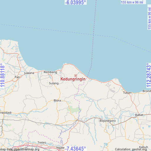
Kedungringin GPS coordinates[2]
6° 44' 19.32" South, 111° 35' 3.48" East
| Map corner | latitude | longitude |
|---|---|---|
| Upper-left | -6.03995°, | 110.88118° |
| Center: | -6.7387°, | 111.5843° |
| Lower-right: | -7.43645°, | 112.28743° |
| Map W x H: | 155.3×155.3 km | = 96.5×96.5mi |
| max Lat: | 5.88969° ⇑21.3% North |
| Kedungringin: | -6.7387° |
| min Lat: | ⇓78.7% South -10.934° |
| min Long | Kedungringin | max Long |
| 95.1345° | 111.5843° | 140.9419° |
| W 43.6%⇐ | ⇒56.4% E |
Elevation
Elevation of Kedungringin is 27 m = 89 ft, and this is 202.7 m = 665 ft below average elevation for this country.
| Max E: |
3185 m = 10449 ft | 73.4% |
| Avg. | 229.7 m = 754 ft | |
| Kedungringin | 27 m = 89 ft | |
Min E: |
-1 m = -3 ft | 26.6% |
See also: Indonesia elevation on elevation.city.
Geographical zone
Kedungringin is located in South Torrid zone (between Equator and Tropic of Capricorn). Distance of Equator is 749.3 km =465.6 mi to North.| Distance of | km | miles | from Kedungringin |
|---|---|---|---|
| Equator | 749.3 | 465.6 | to North |
| Tropic Capricorn | 1856.6 | 1153.6 | to South |
| Antarctic Circle | 6651.9 | 4133.3 | to South |
| South Pole | 9257.8 | 5752.5 | to South |


Nearby cities:
15 places around Kedungringin: (largest is in red/bold)
• Balongteki
3.7 km =2.3 mi,  102°
102°
• Bogorejo
2.9 km =1.8 mi,  293°
293°
• Gobreh
2.2 km =1.4 mi,  149°
149°
• Jambeyan
1.1 km =0.7 mi,  340°
340°
• Karangasem
1.9 km =1.2 mi,  186°
186°
• Kedungdowo
2.8 km =1.7 mi,  198°
198°
• Krajan Gandrirejo
2.3 km =1.4 mi,  298°
298°
• Krajanpondong
2.8 km =1.7 mi,  234°
234°
• Menara
1.4 km =0.9 mi,  35°
35°
• Mojokerto
2.8 km =1.7 mi,  77°
77°
• Ngasinan
2.7 km =1.7 mi,  5°
5°
• Nglojo
3.7 km =2.3 mi,  109°
109°
• Sedan
3.3 km =2.1 mi, 199°
• Sendangwaru
3.7 km =2.3 mi, 342°
• Sulo
1.5 km =0.9 mi,  306°
306°
Sources, notices
• [Note1] Compared only with cities in Indonesia existing in our database
• [Src1] Map data: © OpenStreetMap contributors (CC-BY-SA)
• [Src2] Other city data from geonames.org with taken over terms of usage.
• [Src3] Geographical zone / Annual Mean Temperature by Robert A. Rohde @ Wikipedia
