Sopla geodata
Sopla (West Java) is a seat of a fourth-order administrative division; located in Indonesia in Asia/Jakarta (GMT+7) time zone. In our database, there are 407 cities with bigger population. Compared to other cities in Indonesia, 56.5% of cities are located further ↑North; 69.2% of cities are located further →East and 79.9% of cities have higher elevation than Sopla. Note1


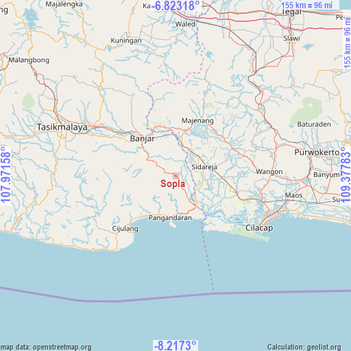
Sopla GPS coordinates[2]
7° 31' 14.88" South, 108° 40' 28.92" East
| Map corner | latitude | longitude |
|---|---|---|
| Upper-left | -6.82318°, | 107.97158° |
| Center: | -7.5208°, | 108.6747° |
| Lower-right: | -8.2173°, | 109.37783° |
| Map W x H: | 155×155 km | = 96.3×96.3mi |
| max Lat: | 5.88969° ⇑56.5% North |
| Sopla: | -7.5208° |
| min Lat: | ⇓43.5% South -10.934° |
| min Long | Sopla | max Long |
| 95.1345° | 108.6747° | 140.9419° |
| W 30.8%⇐ | ⇒69.2% E |
Elevation
Elevation of Sopla is 19 m = 62 ft, and this is 210.7 m = 691 ft below average elevation for this country.
| Max E: |
3185 m = 10449 ft | 79.9% |
| Avg. | 229.7 m = 754 ft | |
| Sopla | 19 m = 62 ft | |
Min E: |
-1 m = -3 ft | 20.1% |
See also: Indonesia elevation on elevation.city.
Geographical zone
Sopla is located in South Torrid zone (between Equator and Tropic of Capricorn). Distance of Equator is 836.2 km =519.6 mi to North.| Distance of | km | miles | from Sopla |
|---|---|---|---|
| Equator | 836.2 | 519.6 | to North |
| Tropic Capricorn | 1769.7 | 1099.6 | to South |
| Antarctic Circle | 6564.9 | 4079.2 | to South |
| South Pole | 9170.8 | 5698.5 | to South |


Nearby cities:
15 places around Sopla: (largest is in red/bold)
• Burujul
3 km =1.9 mi,  158°
158°
• Cangkring
4.8 km =3 mi,  282°
282°
• Cibeureum
1.2 km =0.7 mi,  53°
53°
• Cicapar
3 km =1.9 mi,  286°
286°
• Cinangka
4.6 km =2.9 mi,  210°
210°
• Ciulu
2.5 km =1.6 mi, 290°
• Cogekan
5.9 km =3.7 mi, 53°
• Jangraga
3.8 km =2.4 mi,  353°
353°
• Kedungwuluh
2.2 km =1.4 mi,  140°
140°
• Mangunjaya
4.5 km =2.8 mi,  35°
35°
• Nagrak
5.2 km =3.2 mi, 155°
• Padaherang
4 km =2.5 mi, 144°
• Pasirgeulis
1.2 km =0.7 mi, 354°
• Patingen Dua
3.4 km =2.1 mi,  133°
133°
• Sindangjaya
4.6 km =2.9 mi,  341°
341°
Sources, notices
• [Note1] Compared only with cities in Indonesia existing in our database
• [Src1] Map data: © OpenStreetMap contributors (CC-BY-SA)
• [Src2] Other city data from geonames.org with taken over terms of usage.
• [Src3] Geographical zone / Annual Mean Temperature by Robert A. Rohde @ Wikipedia
