Cintamaju geodata
Cintamaju (West Java) is a seat of a fourth-order administrative division; located in Indonesia in Asia/Jakarta (GMT+7) time zone. In our database, there are 407 cities with bigger population. Compared to other cities in Indonesia, 58.3% of cities are located further ↑North; 68.7% of cities are located further →East and 89% of cities have higher elevation than Cintamaju. Note1


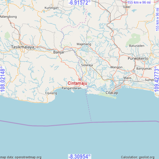
Cintamaju GPS coordinates[2]
7° 36' 47.52" South, 108° 43' 28.56" East
| Map corner | latitude | longitude |
|---|---|---|
| Upper-left | -6.91572°, | 108.02148° |
| Center: | -7.6132°, | 108.7246° |
| Lower-right: | -8.30954°, | 109.42773° |
| Map W x H: | 155×155 km | = 96.3×96.3mi |
| max Lat: | 5.88969° ⇑58.3% North |
| Cintamaju: | -7.6132° |
| min Lat: | ⇓41.7% South -10.934° |
| min Long | Cintamaju | max Long |
| 95.1345° | 108.7246° | 140.9419° |
| W 31.3%⇐ | ⇒68.7% E |
Elevation
Elevation of Cintamaju is 11 m = 36 ft, and this is 218.7 m = 718 ft below average elevation for this country.
| Max E: |
3185 m = 10449 ft | 89% |
| Avg. | 229.7 m = 754 ft | |
| Cintamaju | 11 m = 36 ft | |
Min E: |
-1 m = -3 ft | 11% |
See also: Indonesia elevation on elevation.city.
Geographical zone
Cintamaju is located in South Torrid zone (between Equator and Tropic of Capricorn). Distance of Equator is 846.5 km =526 mi to North.| Distance of | km | miles | from Cintamaju |
|---|---|---|---|
| Equator | 846.5 | 526 | to North |
| Tropic Capricorn | 1759.4 | 1093.2 | to South |
| Antarctic Circle | 6554.7 | 4072.9 | to South |
| South Pole | 9160.6 | 5692.1 | to South |


Nearby cities:
15 places around Cintamaju: (largest is in red/bold)
• Bulakbanjar
1.3 km =0.8 mi,  201°
201°
• Cibuluh Satu
3.5 km =2.2 mi,  148°
148°
• Cihideung
3.3 km =2.1 mi,  339°
339°
• Cinyawang
6.3 km =3.9 mi,  46°
46°
• Ciparakan
6.1 km =3.8 mi,  286°
286°
• Emplak
5.3 km =3.3 mi,  173°
173°
• Kalenpring
5.1 km =3.2 mi, 52°
• Kalipucang
4.6 km =2.9 mi,  137°
137°
• Kawarasan
5.5 km =3.4 mi,  330°
330°
• Kedungsalam
3.4 km =2.1 mi,  83°
83°
• Nagrak
6.5 km =4 mi, 329°
• Patimuan
3.8 km =2.4 mi,  63°
63°
• Purwodadi
4.2 km =2.6 mi,  72°
72°
• Rawaapu
4.6 km =2.9 mi,  128°
128°
• Sentul
6.2 km =3.9 mi,  13°
13°
Sources, notices
• [Note1] Compared only with cities in Indonesia existing in our database
• [Src1] Map data: © OpenStreetMap contributors (CC-BY-SA)
• [Src2] Other city data from geonames.org with taken over terms of usage.
• [Src3] Geographical zone / Annual Mean Temperature by Robert A. Rohde @ Wikipedia
