Sentul geodata
Sentul (West Java) is a seat of a fourth-order administrative division; located in Indonesia in Asia/Jakarta (GMT+7) time zone. In our database, there are 407 cities with bigger population. Compared to other cities in Indonesia, 57.3% of cities are located further ↑North; 68.5% of cities are located further →East and 73.4% of cities have higher elevation than Sentul. Note1


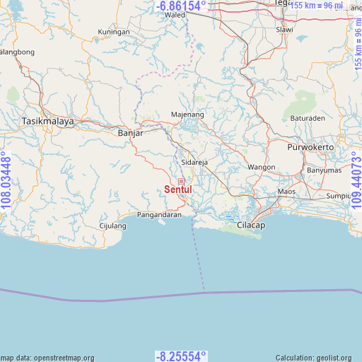
Sentul GPS coordinates[2]
7° 33' 32.76" South, 108° 44' 15.36" East
| Map corner | latitude | longitude |
|---|---|---|
| Upper-left | -6.86154°, | 108.03448° |
| Center: | -7.5591°, | 108.7376° |
| Lower-right: | -8.25554°, | 109.44073° |
| Map W x H: | 155×155 km | = 96.3×96.3mi |
| max Lat: | 5.88969° ⇑57.3% North |
| Sentul: | -7.5591° |
| min Lat: | ⇓42.7% South -10.934° |
| min Long | Sentul | max Long |
| 95.1345° | 108.7376° | 140.9419° |
| W 31.5%⇐ | ⇒68.5% E |
Elevation
Elevation of Sentul is 27 m = 89 ft, and this is 202.7 m = 665 ft below average elevation for this country.
| Max E: |
3185 m = 10449 ft | 73.4% |
| Avg. | 229.7 m = 754 ft | |
| Sentul | 27 m = 89 ft | |
Min E: |
-1 m = -3 ft | 26.6% |
See also: Indonesia elevation on elevation.city.
Geographical zone
Sentul is located in South Torrid zone (between Equator and Tropic of Capricorn). Distance of Equator is 840.5 km =522.3 mi to North.| Distance of | km | miles | from Sentul |
|---|---|---|---|
| Equator | 840.5 | 522.3 | to North |
| Tropic Capricorn | 1765.4 | 1097 | to South |
| Antarctic Circle | 6560.7 | 4076.6 | to South |
| South Pole | 9166.6 | 5695.9 | to South |


Nearby cities:
15 places around Sentul: (largest is in red/bold)
• Cihideung
3.9 km =2.4 mi,  220°
220°
• Ciilat
2.4 km =1.5 mi,  327°
327°
• Cinyawang
3.6 km =2.2 mi,  118°
118°
• Kalenaren
5.7 km =3.5 mi,  113°
113°
• Kalenpring
3.9 km =2.4 mi,  138°
138°
• Kawarasan
4.3 km =2.7 mi,  253°
253°
• Kedungbulu
5.6 km =3.5 mi,  65°
65°
• Kedungsalam
6 km =3.7 mi,  160°
160°
• Maruyungsari
4.7 km =2.9 mi,  350°
350°
• Nagrak
4.8 km =3 mi,  264°
264°
• Padaherang
4.7 km =2.9 mi,  282°
282°
• Patimuan
4.8 km =3 mi, 156°
• Patingen Dua
4.8 km =3 mi,  293°
293°
• Purwodadi
5.4 km =3.4 mi,  151°
151°
• Sidaurip
2.4 km =1.5 mi,  35°
35°
Sources, notices
• [Note1] Compared only with cities in Indonesia existing in our database
• [Src1] Map data: © OpenStreetMap contributors (CC-BY-SA)
• [Src2] Other city data from geonames.org with taken over terms of usage.
• [Src3] Geographical zone / Annual Mean Temperature by Robert A. Rohde @ Wikipedia
