Banjarharja geodata
Banjarharja (West Java) is a seat of a fourth-order administrative division; located in Indonesia in Asia/Jakarta (GMT+7) time zone. In our database, there are 407 cities with bigger population. Compared to other cities in Indonesia, 53.8% of cities are located further ↑North; 69.3% of cities are located further →East and 87.7% of cities have higher elevation than Banjarharja. Note1


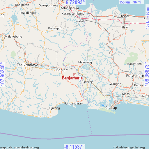
Banjarharja GPS coordinates[2]
7° 25' 7.32" South, 108° 39' 56.16" East
| Map corner | latitude | longitude |
|---|---|---|
| Upper-left | -6.72093°, | 107.96248° |
| Center: | -7.4187°, | 108.6656° |
| Lower-right: | -8.11537°, | 109.36873° |
| Map W x H: | 155×155.1 km | = 96.3×96.4mi |
| max Lat: | 5.88969° ⇑53.8% North |
| Banjarharja: | -7.4187° |
| min Lat: | ⇓46.2% South -10.934° |
| min Long | Banjarharja | max Long |
| 95.1345° | 108.6656° | 140.9419° |
| W 30.7%⇐ | ⇒69.3% E |
Elevation
Elevation of Banjarharja is 12 m = 39 ft, and this is 217.7 m = 714 ft below average elevation for this country.
| Max E: |
3185 m = 10449 ft | 87.7% |
| Avg. | 229.7 m = 754 ft | |
| Banjarharja | 12 m = 39 ft | |
Min E: |
-1 m = -3 ft | 12.3% |
See also: Indonesia elevation on elevation.city.
Geographical zone
Banjarharja is located in South Torrid zone (between Equator and Tropic of Capricorn). Distance of Equator is 824.9 km =512.6 mi to North.| Distance of | km | miles | from Banjarharja |
|---|---|---|---|
| Equator | 824.9 | 512.6 | to North |
| Tropic Capricorn | 1781 | 1106.7 | to South |
| Antarctic Circle | 6576.3 | 4086.3 | to South |
| South Pole | 9182.2 | 5705.6 | to South |


Nearby cities:
15 places around Banjarharja: (largest is in red/bold)
• Baregbeg
2.7 km =1.7 mi,  44°
44°
• Cakungsari
4.7 km =2.9 mi,  213°
213°
• Ciawitali
3.5 km =2.2 mi,  199°
199°
• Cilongkrang
5.3 km =3.3 mi,  77°
77°
• Jamban
3.3 km =2.1 mi,  93°
93°
• Kalapagada
2.8 km =1.7 mi,  350°
350°
• Karangpaningal
2 km =1.2 mi,  177°
177°
• Lakbok
1.9 km =1.2 mi,  330°
330°
• Meluwung
4.8 km =3 mi,  54°
54°
• Pondokunyur
3.5 km =2.2 mi,  18°
18°
• Sindangrasa
5.1 km =3.2 mi,  151°
151°
• Sukaharja
4.6 km =2.9 mi,  253°
253°
• Sukanagara
2 km =1.2 mi, 326°
• Talangbanteng
5.1 km =3.2 mi,  125°
125°
• Tambakreja
4.1 km =2.5 mi, 346°
Sources, notices
• [Note1] Compared only with cities in Indonesia existing in our database
• [Src1] Map data: © OpenStreetMap contributors (CC-BY-SA)
• [Src2] Other city data from geonames.org with taken over terms of usage.
• [Src3] Geographical zone / Annual Mean Temperature by Robert A. Rohde @ Wikipedia
