Meluwung geodata
Meluwung (Central Java) is a seat of a fourth-order administrative division; located in Indonesia in Asia/Jakarta (GMT+7) time zone. In our database, there are 407 cities with bigger population. Compared to other cities in Indonesia, 53% of cities are located further ↑North; 68.9% of cities are located further →East and 78.1% of cities have higher elevation than Meluwung. Note1


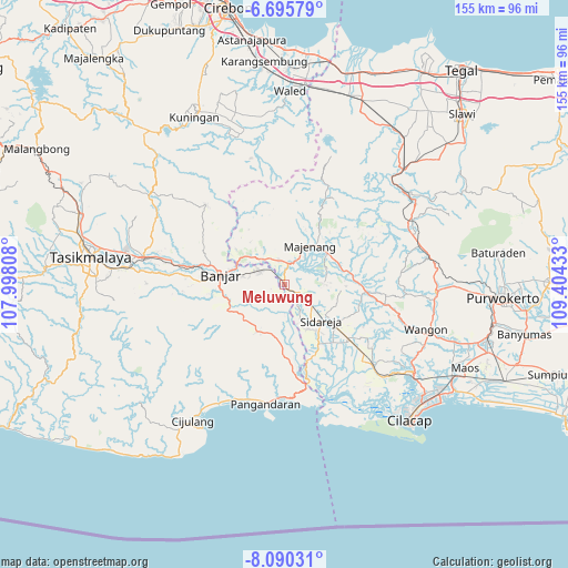
Meluwung GPS coordinates[2]
7° 23' 36.96" South, 108° 42' 4.32" East
| Map corner | latitude | longitude |
|---|---|---|
| Upper-left | -6.69579°, | 107.99808° |
| Center: | -7.3936°, | 108.7012° |
| Lower-right: | -8.09031°, | 109.40433° |
| Map W x H: | 155.1×155.1 km | = 96.4×96.4mi |
| max Lat: | 5.88969° ⇑53% North |
| Meluwung: | -7.3936° |
| min Lat: | ⇓47% South -10.934° |
| min Long | Meluwung | max Long |
| 95.1345° | 108.7012° | 140.9419° |
| W 31.1%⇐ | ⇒68.9% E |
Elevation
Elevation of Meluwung is 21 m = 69 ft, and this is 208.7 m = 685 ft below average elevation for this country.
| Max E: |
3185 m = 10449 ft | 78.1% |
| Avg. | 229.7 m = 754 ft | |
| Meluwung | 21 m = 69 ft | |
Min E: |
-1 m = -3 ft | 21.9% |
See also: Indonesia elevation on elevation.city.
Geographical zone
Meluwung is located in South Torrid zone (between Equator and Tropic of Capricorn). Distance of Equator is 822.1 km =510.8 mi to North.| Distance of | km | miles | from Meluwung |
|---|---|---|---|
| Equator | 822.1 | 510.8 | to North |
| Tropic Capricorn | 1783.8 | 1108.4 | to South |
| Antarctic Circle | 6579.1 | 4088.1 | to South |
| South Pole | 9185 | 5707.3 | to South |


Nearby cities:
15 places around Meluwung: (largest is in red/bold)
• Bakung
5.4 km =3.4 mi,  328°
328°
• Banjarharja
4.8 km =3 mi,  234°
234°
• Baregbeg
2.2 km =1.4 mi,  247°
247°
• Cilongkrang
2.1 km =1.3 mi,  142°
142°
• Cintaratu
3.5 km =2.2 mi,  314°
314°
• Cisuru
4 km =2.5 mi,  97°
97°
• Jamban
3.1 km =1.9 mi,  192°
192°
• Kalapagada
4.4 km =2.7 mi,  268°
268°
• Lakbok
5 km =3.1 mi,  256°
256°
• Pondokunyur
2.8 km =1.7 mi,  281°
281°
• Sarimukti Kaler
4.3 km =2.7 mi,  159°
159°
• Sawangan
5.2 km =3.2 mi, 97°
• Sukanagara
5.1 km =3.2 mi, 257°
• Tambakreja
5.1 km =3.2 mi, 284°
• Winangun
4.1 km =2.5 mi,  2°
2°
Sources, notices
• [Note1] Compared only with cities in Indonesia existing in our database
• [Src1] Map data: © OpenStreetMap contributors (CC-BY-SA)
• [Src2] Other city data from geonames.org with taken over terms of usage.
• [Src3] Geographical zone / Annual Mean Temperature by Robert A. Rohde @ Wikipedia
