Karanganyar geodata
Karanganyar (Central Java) is a seat of a fourth-order administrative division; located in Indonesia in Asia/Jakarta (GMT+7) time zone. In our database, there are 407 cities with bigger population. Compared to other cities in Indonesia, 76.6% of cities are located further ↓South; 59.7% of cities are located further →East and 66.8% of cities have higher elevation than Karanganyar. Note1


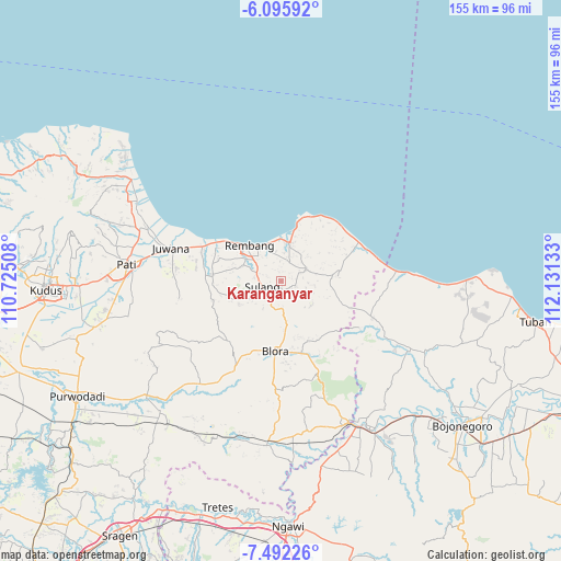
Karanganyar GPS coordinates[2]
6° 47' 40.56" South, 111° 25' 41.52" East
| Map corner | latitude | longitude |
|---|---|---|
| Upper-left | -6.09592°, | 110.72508° |
| Center: | -6.7946°, | 111.4282° |
| Lower-right: | -7.49226°, | 112.13133° |
| Map W x H: | 155.3×155.3 km | = 96.5×96.5mi |
| max Lat: | 5.88969° ⇑23.4% North |
| Karanganyar: | -6.7946° |
| min Lat: | ⇓76.6% South -10.934° |
| min Long | Karanganyar | max Long |
| 95.1345° | 111.4282° | 140.9419° |
| W 40.3%⇐ | ⇒59.7% E |
Elevation
Elevation of Karanganyar is 38 m = 125 ft, and this is 191.7 m = 629 ft below average elevation for this country.
| Max E: |
3185 m = 10449 ft | 66.8% |
| Avg. | 229.7 m = 754 ft | |
| Karanganyar | 38 m = 125 ft | |
Min E: |
-1 m = -3 ft | 33.2% |
See also: Indonesia elevation on elevation.city.
Geographical zone
Karanganyar is located in South Torrid zone (between Equator and Tropic of Capricorn). Distance of Equator is 755.5 km =469.4 mi to North.| Distance of | km | miles | from Karanganyar |
|---|---|---|---|
| Equator | 755.5 | 469.4 | to North |
| Tropic Capricorn | 1850.4 | 1149.8 | to South |
| Antarctic Circle | 6645.7 | 4129.4 | to South |
| South Pole | 9251.6 | 5748.7 | to South |


Nearby cities:
15 places around Karanganyar: (largest is in red/bold)
• Banyuurip
2.5 km =1.6 mi,  203°
203°
• Demaan
1.4 km =0.9 mi,  170°
170°
• Kembang
2.6 km =1.6 mi,  7°
7°
• Kepohagung
2.9 km =1.8 mi,  342°
342°
• Korowelang
1.3 km =0.8 mi,  295°
295°
• Mlagen
1.4 km =0.9 mi, 341°
• Mlawat
2.4 km =1.5 mi,  331°
331°
• Ngemplakrejo Lor
3 km =1.9 mi,  77°
77°
• Panohan
2.5 km =1.6 mi,  156°
156°
• Pomahan
2.7 km =1.7 mi,  218°
218°
• Rukem
1.7 km =1.1 mi,  237°
237°
• Sambong
1 km =0.6 mi, 243°
• Sendangmulyo
3 km =1.9 mi,  137°
137°
• Tempaling
3 km =1.9 mi,  44°
44°
• Tempel
2.5 km =1.6 mi,  65°
65°
Sources, notices
• [Note1] Compared only with cities in Indonesia existing in our database
• [Src1] Map data: © OpenStreetMap contributors (CC-BY-SA)
• [Src2] Other city data from geonames.org with taken over terms of usage.
• [Src3] Geographical zone / Annual Mean Temperature by Robert A. Rohde @ Wikipedia
