Panohan geodata
Panohan (Central Java) is a seat of a fourth-order administrative division; located in Indonesia in Asia/Jakarta (GMT+7) time zone. In our database, there are 407 cities with bigger population. Compared to other cities in Indonesia, 75.7% of cities are located further ↓South; 59.5% of cities are located further →East and 60.1% of cities have higher elevation than Panohan. Note1


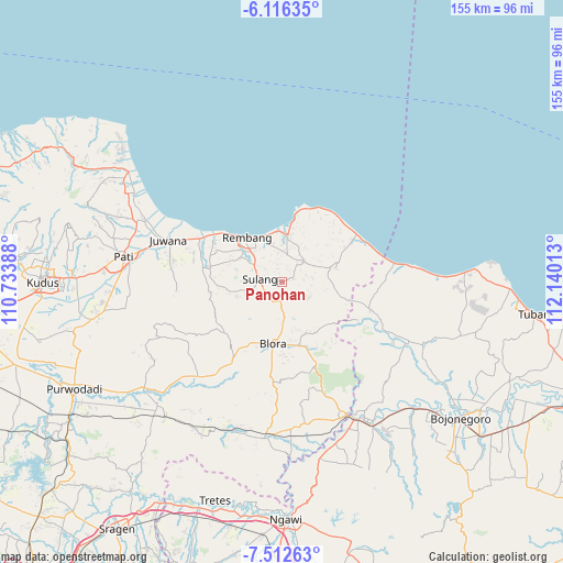
Panohan GPS coordinates[2]
6° 48' 54" South, 111° 26' 13.2" East
| Map corner | latitude | longitude |
|---|---|---|
| Upper-left | -6.11635°, | 110.73388° |
| Center: | -6.815°, | 111.437° |
| Lower-right: | -7.51263°, | 112.14013° |
| Map W x H: | 155.3×155.3 km | = 96.5×96.5mi |
| max Lat: | 5.88969° ⇑24.3% North |
| Panohan: | -6.815° |
| min Lat: | ⇓75.7% South -10.934° |
| min Long | Panohan | max Long |
| 95.1345° | 111.437° | 140.9419° |
| W 40.5%⇐ | ⇒59.5% E |
Elevation
Elevation of Panohan is 59 m = 194 ft, and this is 170.7 m = 560 ft below average elevation for this country.
| Max E: |
3185 m = 10449 ft | 60.1% |
| Avg. | 229.7 m = 754 ft | |
| Panohan | 59 m = 194 ft | |
Min E: |
-1 m = -3 ft | 39.9% |
See also: Indonesia elevation on elevation.city.
Geographical zone
Panohan is located in South Torrid zone (between Equator and Tropic of Capricorn). Distance of Equator is 757.8 km =470.9 mi to North.| Distance of | km | miles | from Panohan |
|---|---|---|---|
| Equator | 757.8 | 470.9 | to North |
| Tropic Capricorn | 1848.2 | 1148.4 | to South |
| Antarctic Circle | 6643.4 | 4128 | to South |
| South Pole | 9249.3 | 5747.2 | to South |


Nearby cities:
15 places around Panohan: (largest is in red/bold)
• Banyuurip
2 km =1.2 mi,  270°
270°
• Demaan
1.1 km =0.7 mi,  319°
319°
• Gunem
3.3 km =2.1 mi,  74°
74°
• Karanganyar
2.5 km =1.6 mi,  336°
336°
• Korowelang
3.5 km =2.2 mi, 322°
• Kulutan
3.5 km =2.2 mi,  60°
60°
• Mlagen
3.8 km =2.4 mi, 338°
• Ngemplakrejo Lor
3.5 km =2.2 mi,  34°
34°
• Pomahan
2.7 km =1.7 mi, 272°
• Rukem
2.8 km =1.7 mi,  298°
298°
• Sambong
2.6 km =1.6 mi,  314°
314°
• Sendangmulyo
1 km =0.6 mi,  84°
84°
• Sidomulyo
2.8 km =1.7 mi, 68°
• Telgawah
1.9 km =1.2 mi, 83°
• Tempel
3.5 km =2.2 mi,  20°
20°
Sources, notices
• [Note1] Compared only with cities in Indonesia existing in our database
• [Src1] Map data: © OpenStreetMap contributors (CC-BY-SA)
• [Src2] Other city data from geonames.org with taken over terms of usage.
• [Src3] Geographical zone / Annual Mean Temperature by Robert A. Rohde @ Wikipedia
