Nglarohgunung geodata
Nglarohgunung (Central Java) is a seat of a fourth-order administrative division; located in Indonesia in Asia/Jakarta (GMT+7) time zone. In our database, there are 407 cities with bigger population. Compared to other cities in Indonesia, 68.8% of cities are located further ↓South; 58.3% of cities are located further →East and 55% of cities have lower elevation than Nglarohgunung. Note1


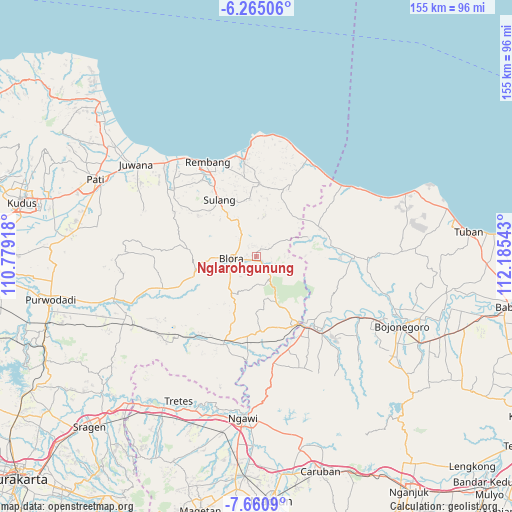
Nglarohgunung GPS coordinates[2]
6° 57' 48.6" South, 111° 28' 56.28" East
| Map corner | latitude | longitude |
|---|---|---|
| Upper-left | -6.26506°, | 110.77918° |
| Center: | -6.9635°, | 111.4823° |
| Lower-right: | -7.6609°, | 112.18543° |
| Map W x H: | 155.2×155.2 km | = 96.4×96.4mi |
| max Lat: | 5.88969° ⇑31.2% North |
| Nglarohgunung: | -6.9635° |
| min Lat: | ⇓68.8% South -10.934° |
| min Long | Nglarohgunung | max Long |
| 95.1345° | 111.4823° | 140.9419° |
| W 41.7%⇐ | ⇒58.3% E |
Elevation
Elevation of Nglarohgunung is 125 m = 410 ft, and this is 104.7 m = 344 ft below average elevation for this country.
| Max E: |
3185 m = 10449 ft | 45% |
| Avg. | 229.7 m = 754 ft | |
| Nglarohgunung | 125 m = 410 ft | |
Min E: |
-1 m = -3 ft | 55% |
See also: Indonesia elevation on elevation.city.
Geographical zone
Nglarohgunung is located in South Torrid zone (between Equator and Tropic of Capricorn). Distance of Equator is 774.3 km =481.1 mi to North.| Distance of | km | miles | from Nglarohgunung |
|---|---|---|---|
| Equator | 774.3 | 481.1 | to North |
| Tropic Capricorn | 1831.7 | 1138.2 | to South |
| Antarctic Circle | 6626.9 | 4117.8 | to South |
| South Pole | 9232.8 | 5737 | to South |


Nearby cities:
15 places around Nglarohgunung: (largest is in red/bold)
• Cangkringan
3 km =1.9 mi,  241°
241°
• Gendangdowo
3.3 km =2.1 mi,  300°
300°
• Gersi
2.9 km =1.8 mi,  283°
283°
• Gombang
2.6 km =1.6 mi,  8°
8°
• Gondang
2.1 km =1.3 mi,  270°
270°
• Jepon
1.1 km =0.7 mi,  196°
196°
• Jeponkrajan
1.8 km =1.1 mi,  191°
191°
• Karang
3.2 km =2 mi,  29°
29°
• Kawengan
3 km =1.9 mi,  338°
338°
• Kemiri
3.1 km =1.9 mi,  169°
169°
• Prantaan
2.6 km =1.6 mi,  42°
42°
• Semampir
2.8 km =1.7 mi,  178°
178°
• Seso
3.1 km =1.9 mi,  260°
260°
• Tempel
2.2 km =1.4 mi,  135°
135°
• Turirejo
3.2 km =2 mi,  217°
217°
Sources, notices
• [Note1] Compared only with cities in Indonesia existing in our database
• [Src1] Map data: © OpenStreetMap contributors (CC-BY-SA)
• [Src2] Other city data from geonames.org with taken over terms of usage.
• [Src3] Geographical zone / Annual Mean Temperature by Robert A. Rohde @ Wikipedia
