Kablukan geodata
Kablukan (East Java) is a seat of a fourth-order administrative division; located in Indonesia in Asia/Jakarta (GMT+7) time zone. In our database, there are 407 cities with bigger population. Compared to other cities in Indonesia, 67.3% of cities are located further ↓South; 54.3% of cities are located further →East and 61.3% of cities have higher elevation than Kablukan. Note1


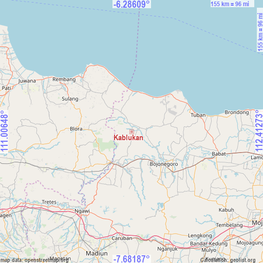
Kablukan GPS coordinates[2]
6° 59' 4.2" South, 111° 42' 34.56" East
| Map corner | latitude | longitude |
|---|---|---|
| Upper-left | -6.28609°, | 111.00648° |
| Center: | -6.9845°, | 111.7096° |
| Lower-right: | -7.68187°, | 112.41273° |
| Map W x H: | 155.2×155.2 km | = 96.4×96.4mi |
| max Lat: | 5.88969° ⇑32.7% North |
| Kablukan: | -6.9845° |
| min Lat: | ⇓67.3% South -10.934° |
| min Long | Kablukan | max Long |
| 95.1345° | 111.7096° | 140.9419° |
| W 45.7%⇐ | ⇒54.3% E |
Elevation
Elevation of Kablukan is 54 m = 177 ft, and this is 175.7 m = 576 ft below average elevation for this country.
| Max E: |
3185 m = 10449 ft | 61.3% |
| Avg. | 229.7 m = 754 ft | |
| Kablukan | 54 m = 177 ft | |
Min E: |
-1 m = -3 ft | 38.7% |
See also: Indonesia elevation on elevation.city.
Geographical zone
Kablukan is located in South Torrid zone (between Equator and Tropic of Capricorn). Distance of Equator is 776.6 km =482.6 mi to North.| Distance of | km | miles | from Kablukan |
|---|---|---|---|
| Equator | 776.6 | 482.6 | to North |
| Tropic Capricorn | 1829.3 | 1136.7 | to South |
| Antarctic Circle | 6624.6 | 4116.3 | to South |
| South Pole | 9230.5 | 5735.6 | to South |


Nearby cities:
15 places around Kablukan: (largest is in red/bold)
• Bangilan
1.7 km =1.1 mi,  17°
17°
• Banjarworo
3.5 km =2.2 mi,  11°
11°
• Bate
2.7 km =1.7 mi,  243°
243°
• Kedungharjo
1.7 km =1.1 mi,  62°
62°
• Kedungmulyo
3.2 km =2 mi, 18°
• Kejuron
3 km =1.9 mi,  300°
300°
• Klakeh
2.8 km =1.7 mi,  284°
284°
• Krajan Weden
1.5 km =0.9 mi,  69°
69°
• Medalem
2 km =1.2 mi,  166°
166°
• Mundri
3.2 km =2 mi,  0°
0°
• Ngrojo
0.9 km =0.6 mi, 68°
• Sendang
3.4 km =2.1 mi,  136°
136°
• Senori
3.8 km =2.4 mi,  154°
154°
• Sumuragung
2.3 km =1.4 mi, 9°
• Talok
0.8 km =0.5 mi, 8°
Sources, notices
• [Note1] Compared only with cities in Indonesia existing in our database
• [Src1] Map data: © OpenStreetMap contributors (CC-BY-SA)
• [Src2] Other city data from geonames.org with taken over terms of usage.
• [Src3] Geographical zone / Annual Mean Temperature by Robert A. Rohde @ Wikipedia
