Cigintung geodata
Cigintung (Central Java) is a seat of a fourth-order administrative division; located in Indonesia in Asia/Jakarta (GMT+7) time zone. In our database, there are 407 cities with bigger population. Compared to other cities in Indonesia, 52.4% of cities are located further ↑North; 67.7% of cities are located further →East and 69.5% of cities have higher elevation than Cigintung. Note1


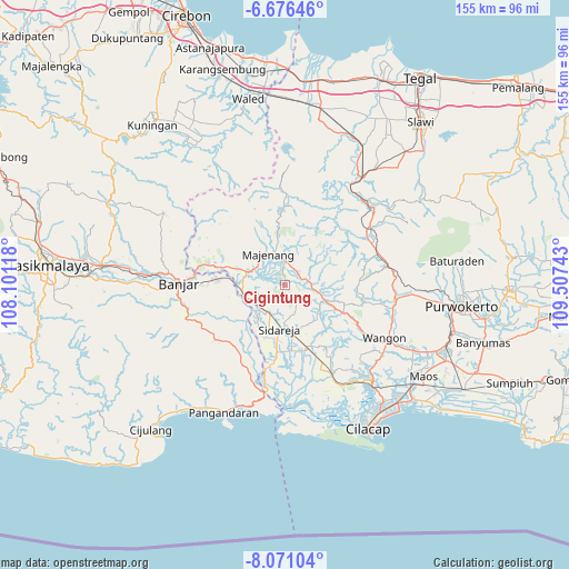
Cigintung GPS coordinates[2]
7° 22' 27.48" South, 108° 48' 15.48" East
| Map corner | latitude | longitude |
|---|---|---|
| Upper-left | -6.67646°, | 108.10118° |
| Center: | -7.3743°, | 108.8043° |
| Lower-right: | -8.07104°, | 109.50743° |
| Map W x H: | 155.1×155.1 km | = 96.4×96.4mi |
| max Lat: | 5.88969° ⇑52.4% North |
| Cigintung: | -7.3743° |
| min Lat: | ⇓47.6% South -10.934° |
| min Long | Cigintung | max Long |
| 95.1345° | 108.8043° | 140.9419° |
| W 32.3%⇐ | ⇒67.7% E |
Elevation
Elevation of Cigintung is 33 m = 108 ft, and this is 196.7 m = 645 ft below average elevation for this country.
| Max E: |
3185 m = 10449 ft | 69.5% |
| Avg. | 229.7 m = 754 ft | |
| Cigintung | 33 m = 108 ft | |
Min E: |
-1 m = -3 ft | 30.5% |
See also: Indonesia elevation on elevation.city.
Geographical zone
Cigintung is located in South Torrid zone (between Equator and Tropic of Capricorn). Distance of Equator is 819.9 km =509.5 mi to North.| Distance of | km | miles | from Cigintung |
|---|---|---|---|
| Equator | 819.9 | 509.5 | to North |
| Tropic Capricorn | 1786 | 1109.8 | to South |
| Antarctic Circle | 6581.2 | 4089.4 | to South |
| South Pole | 9187.1 | 5708.6 | to South |


Nearby cities:
15 places around Cigintung: (largest is in red/bold)
• Cibatu
6.1 km =3.8 mi,  233°
233°
• Cidadap
5.9 km =3.7 mi,  115°
115°
• Cilempuyang
4.8 km =3 mi,  41°
41°
• Cimanggu
4.6 km =2.9 mi,  58°
58°
• Cimanggu Wetan
4.8 km =3 mi, 56°
• Genteng Wetan
6.8 km =4.2 mi,  83°
83°
• Gunungwilis
5.1 km =3.2 mi,  181°
181°
• Karangtengah Lor
2.2 km =1.4 mi,  0°
0°
• Kubangwaru
5.5 km =3.4 mi,  355°
355°
• Kutasari
7.2 km =4.5 mi,  340°
340°
• Padangsari
5.3 km =3.3 mi,  327°
327°
• Purwosari
2.7 km =1.7 mi,  240°
240°
• Sawangan
6.8 km =4.2 mi,  245°
245°
• Sindanghaji
5.9 km =3.7 mi, 75°
• Tawangsari
2.4 km =1.5 mi, 179°
Sources, notices
• [Note1] Compared only with cities in Indonesia existing in our database
• [Src1] Map data: © OpenStreetMap contributors (CC-BY-SA)
• [Src2] Other city data from geonames.org with taken over terms of usage.
• [Src3] Geographical zone / Annual Mean Temperature by Robert A. Rohde @ Wikipedia
