Gunungwilis geodata
Gunungwilis (Central Java) is a seat of a fourth-order administrative division; located in Indonesia in Asia/Jakarta (GMT+7) time zone. In our database, there are 407 cities with bigger population. Compared to other cities in Indonesia, 53.8% of cities are located further ↑North; 67.7% of cities are located further →East and 56% of cities have lower elevation than Gunungwilis. Note1


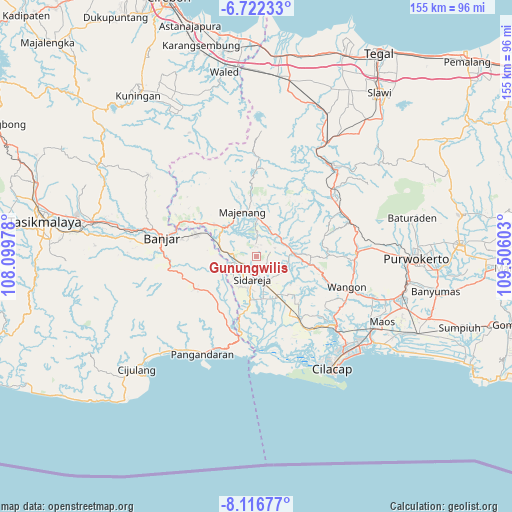
Gunungwilis GPS coordinates[2]
7° 25' 12.36" South, 108° 48' 10.44" East
| Map corner | latitude | longitude |
|---|---|---|
| Upper-left | -6.72233°, | 108.09978° |
| Center: | -7.4201°, | 108.8029° |
| Lower-right: | -8.11677°, | 109.50603° |
| Map W x H: | 155×155.1 km | = 96.3×96.4mi |
| max Lat: | 5.88969° ⇑53.8% North |
| Gunungwilis: | -7.4201° |
| min Lat: | ⇓46.2% South -10.934° |
| min Long | Gunungwilis | max Long |
| 95.1345° | 108.8029° | 140.9419° |
| W 32.3%⇐ | ⇒67.7% E |
Elevation
Elevation of Gunungwilis is 130 m = 427 ft, and this is 99.7 m = 327 ft below average elevation for this country.
| Max E: |
3185 m = 10449 ft | 44% |
| Avg. | 229.7 m = 754 ft | |
| Gunungwilis | 130 m = 427 ft | |
Min E: |
-1 m = -3 ft | 56% |
See also: Indonesia elevation on elevation.city.
Geographical zone
Gunungwilis is located in South Torrid zone (between Equator and Tropic of Capricorn). Distance of Equator is 825 km =512.6 mi to North.| Distance of | km | miles | from Gunungwilis |
|---|---|---|---|
| Equator | 825 | 512.6 | to North |
| Tropic Capricorn | 1780.9 | 1106.6 | to South |
| Antarctic Circle | 6576.1 | 4086.2 | to South |
| South Pole | 9182 | 5705.4 | to South |


Nearby cities:
15 places around Gunungwilis: (largest is in red/bold)
• Candimulya
6.1 km =3.8 mi,  256°
256°
• Cibatu
5 km =3.1 mi,  287°
287°
• Cidadap
6 km =3.7 mi,  65°
65°
• Cigintung
5.1 km =3.2 mi,  1°
1°
• Cikondang
6 km =3.7 mi,  173°
173°
• Cipari
4.8 km =3 mi,  244°
244°
• Dukuhsawah
3.4 km =2.1 mi,  223°
223°
• Karangsalam
3.7 km =2.3 mi,  132°
132°
• Karangtengah
5.2 km =3.2 mi, 241°
• Prumpung
6.5 km =4 mi, 222°
• Purwosari
4.4 km =2.7 mi,  329°
329°
• Rungkang
5.8 km =3.6 mi,  108°
108°
• Sawangan
6.4 km =4 mi, 290°
• Tawangsari
2.7 km =1.7 mi, 3°
• Wonodadi
5.3 km =3.3 mi,  141°
141°
Sources, notices
• [Note1] Compared only with cities in Indonesia existing in our database
• [Src1] Map data: © OpenStreetMap contributors (CC-BY-SA)
• [Src2] Other city data from geonames.org with taken over terms of usage.
• [Src3] Geographical zone / Annual Mean Temperature by Robert A. Rohde @ Wikipedia
