Mulyadadi geodata
Mulyadadi (Central Java) is a seat of a fourth-order administrative division; located in Indonesia in Asia/Jakarta (GMT+7) time zone. In our database, there are 407 cities with bigger population. Compared to other cities in Indonesia, 50.2% of cities are located further ↓South; 68.3% of cities are located further →East and 75.5% of cities have higher elevation than Mulyadadi. Note1


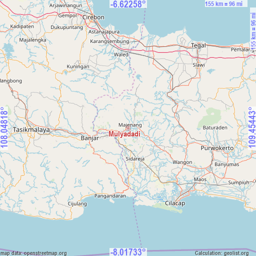
Mulyadadi GPS coordinates[2]
7° 19' 13.8" South, 108° 45' 4.68" East
| Map corner | latitude | longitude |
|---|---|---|
| Upper-left | -6.62258°, | 108.04818° |
| Center: | -7.3205°, | 108.7513° |
| Lower-right: | -8.01733°, | 109.45443° |
| Map W x H: | 155.1×155.1 km | = 96.4×96.4mi |
| max Lat: | 5.88969° ⇑49.8% North |
| Mulyadadi: | -7.3205° |
| min Lat: | ⇓50.2% South -10.934° |
| min Long | Mulyadadi | max Long |
| 95.1345° | 108.7513° | 140.9419° |
| W 31.7%⇐ | ⇒68.3% E |
Elevation
Elevation of Mulyadadi is 24 m = 79 ft, and this is 205.7 m = 675 ft below average elevation for this country.
| Max E: |
3185 m = 10449 ft | 75.5% |
| Avg. | 229.7 m = 754 ft | |
| Mulyadadi | 24 m = 79 ft | |
Min E: |
-1 m = -3 ft | 24.5% |
See also: Indonesia elevation on elevation.city.
Geographical zone
Mulyadadi is located in South Torrid zone (between Equator and Tropic of Capricorn). Distance of Equator is 814 km =505.8 mi to North.| Distance of | km | miles | from Mulyadadi |
|---|---|---|---|
| Equator | 814 | 505.8 | to North |
| Tropic Capricorn | 1792 | 1113.5 | to South |
| Antarctic Circle | 6587.2 | 4093.1 | to South |
| South Pole | 9193.1 | 5712.3 | to South |


Nearby cities:
15 places around Mulyadadi: (largest is in red/bold)
• Bojongsari
1.6 km =1 mi,  49°
49°
• Cibeunying
3.1 km =1.9 mi,  345°
345°
• Cihandiwung Lor
6.9 km =4.3 mi,  257°
257°
• Cilopadang
4.6 km =2.9 mi,  67°
67°
• Cipasang
5.6 km =3.5 mi,  8°
8°
• Jenang Selatan
2.4 km =1.5 mi,  22°
22°
• Karanggedang
3.6 km =2.2 mi,  305°
305°
• Kubangwaru
5.4 km =3.4 mi,  95°
95°
• Kutasari
3.6 km =2.2 mi,  76°
76°
• Limbangan
5 km =3.1 mi,  293°
293°
• Majenang
2.9 km =1.8 mi,  29°
29°
• Padangsari
3.4 km =2.1 mi,  116°
116°
• Pahonjean
1.5 km =0.9 mi,  251°
251°
• Tanjungsari
2.9 km =1.8 mi,  40°
40°
• Winangun
6.7 km =4.2 mi,  232°
232°
Sources, notices
• [Note1] Compared only with cities in Indonesia existing in our database
• [Src1] Map data: © OpenStreetMap contributors (CC-BY-SA)
• [Src2] Other city data from geonames.org with taken over terms of usage.
• [Src3] Geographical zone / Annual Mean Temperature by Robert A. Rohde @ Wikipedia
