Majenang geodata
Majenang (Central Java) is a seat of a third-order administrative division; located in Indonesia in Asia/Jakarta (GMT+7) time zone. With population of 38,897 people, there are 274 cities with bigger population in this country. Compared to other cities in Indonesia, 51.3% of cities are located further ↓South; 68.1% of cities are located further →East and 66.1% of cities have higher elevation than Majenang. Note1


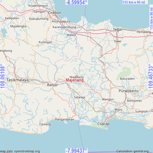
Majenang GPS coordinates[2]
7° 17' 51" South, 108° 45' 51.12" East
| Map corner | latitude | longitude |
|---|---|---|
| Upper-left | -6.59954°, | 108.06108° |
| Center: | -7.2975°, | 108.7642° |
| Lower-right: | -7.99437°, | 109.46733° |
| Map W x H: | 155.1×155.1 km | = 96.4×96.4mi |
| max Lat: | 5.88969° ⇑48.7% North |
| Majenang: | -7.2975° |
| min Lat: | ⇓51.3% South -10.934° |
| min Long | Majenang | max Long |
| 95.1345° | 108.7642° | 140.9419° |
| W 31.9%⇐ | ⇒68.1% E |
Elevation
Elevation of Majenang is 40 m = 131 ft, and this is 189.7 m = 622 ft below average elevation for this country.
| Max E: |
3185 m = 10449 ft | 66.1% |
| Avg. | 229.7 m = 754 ft | |
| Majenang | 40 m = 131 ft | |
Min E: |
-1 m = -3 ft | 33.9% |
See also: Indonesia elevation on elevation.city.
Geographical zone
Majenang is located in South Torrid zone (between Equator and Tropic of Capricorn). Distance of Equator is 811.4 km =504.2 mi to North.| Distance of | km | miles | from Majenang |
|---|---|---|---|
| Equator | 811.4 | 504.2 | to North |
| Tropic Capricorn | 1794.5 | 1115.1 | to South |
| Antarctic Circle | 6589.8 | 4094.7 | to South |
| South Pole | 9195.7 | 5713.9 | to South |


Nearby cities:
15 places around Majenang: (largest is in red/bold)
• Bojongsari
1.5 km =0.9 mi,  186°
186°
• Cibeunying
2.3 km =1.4 mi,  281°
281°
• Cilopadang
2.9 km =1.8 mi,  105°
105°
• Cipasang
3.1 km =1.9 mi,  348°
348°
• Cipeusing
6.2 km =3.9 mi,  57°
57°
• Jenang Selatan
0.6 km =0.4 mi,  237°
237°
• Karanggedang
4.4 km =2.7 mi,  264°
264°
• Kubangwaru
5 km =3.1 mi,  127°
127°
• Kutasari
2.7 km =1.7 mi, 129°
• Limbangan
6 km =3.7 mi, 264°
• Mulyadadi
2.9 km =1.8 mi,  209°
209°
• Padangsari
4.4 km =2.7 mi,  158°
158°
• Pahonjean
4.2 km =2.6 mi,  223°
223°
• Tanjungsari
0.6 km =0.4 mi, 132°
• Walahir
5.2 km =3.2 mi,  24°
24°
Sources, notices
• [Note1] Compared only with cities in Indonesia existing in our database
• [Src1] Map data: © OpenStreetMap contributors (CC-BY-SA)
• [Src2] Other city data from geonames.org with taken over terms of usage.
• [Src3] Geographical zone / Annual Mean Temperature by Robert A. Rohde @ Wikipedia
