Sumurgayam geodata
Sumurgayam (East Java) is a seat of a fourth-order administrative division; located in Indonesia in Asia/Jakarta (GMT+7) time zone. In our database, there are 407 cities with bigger population. Compared to other cities in Indonesia, 73.7% of cities are located further ↓South; 52.7% of cities are located further ←West and 85.2% of cities have higher elevation than Sumurgayam. Note1


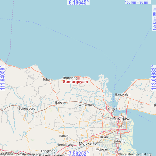
Sumurgayam GPS coordinates[2]
6° 53' 6" South, 112° 20' 37.32" East
| Map corner | latitude | longitude |
|---|---|---|
| Upper-left | -6.18645°, | 111.64058° |
| Center: | -6.885°, | 112.3437° |
| Lower-right: | -7.58252°, | 113.04683° |
| Map W x H: | 155.2×155.2 km | = 96.4×96.4mi |
| max Lat: | 5.88969° ⇑26.3% North |
| Sumurgayam: | -6.885° |
| min Lat: | ⇓73.7% South -10.934° |
| min Long | Sumurgayam | max Long |
| 95.1345° | 112.3437° | 140.9419° |
| W 52.7%⇐ | ⇒47.3% E |
Elevation
Elevation of Sumurgayam is 14 m = 46 ft, and this is 215.7 m = 708 ft below average elevation for this country.
| Max E: |
3185 m = 10449 ft | 85.2% |
| Avg. | 229.7 m = 754 ft | |
| Sumurgayam | 14 m = 46 ft | |
Min E: |
-1 m = -3 ft | 14.8% |
See also: Indonesia elevation on elevation.city.
Geographical zone
Sumurgayam is located in South Torrid zone (between Equator and Tropic of Capricorn). Distance of Equator is 765.5 km =475.7 mi to North.| Distance of | km | miles | from Sumurgayam |
|---|---|---|---|
| Equator | 765.5 | 475.7 | to North |
| Tropic Capricorn | 1840.4 | 1143.6 | to South |
| Antarctic Circle | 6635.6 | 4123.2 | to South |
| South Pole | 9241.5 | 5742.4 | to South |


Nearby cities:
15 places around Sumurgayam: (largest is in red/bold)
• Banjaranyar
5.2 km =3.2 mi,  80°
80°
• Blimbing
5.3 km =3.3 mi,  280°
280°
• Dadapan
5.2 km =3.2 mi,  217°
217°
• Drajat
4.9 km =3 mi,  87°
87°
• Kranji
4.4 km =2.7 mi, 79°
• Paciran
3.7 km =2.3 mi, 75°
• Payaman
3.7 km =2.3 mi,  164°
164°
• Sendangagung
1.6 km =1 mi,  170°
170°
• Sendangduwur
1.3 km =0.8 mi, 162°
• Solokuro
5.6 km =3.5 mi, 165°
• Sugihan
3.9 km =2.4 mi,  208°
208°
• Sumberagung
5.5 km =3.4 mi,  259°
259°
• Tebluru
5.2 km =3.2 mi, 208°
• Tenggulun
5.6 km =3.5 mi,  188°
188°
• Tunggul
3.5 km =2.2 mi,  73°
73°
Sources, notices
• [Note1] Compared only with cities in Indonesia existing in our database
• [Src1] Map data: © OpenStreetMap contributors (CC-BY-SA)
• [Src2] Other city data from geonames.org with taken over terms of usage.
• [Src3] Geographical zone / Annual Mean Temperature by Robert A. Rohde @ Wikipedia
