Drajat geodata
Drajat (East Java) is a seat of a fourth-order administrative division; located in Indonesia in Asia/Jakarta (GMT+7) time zone. In our database, there are 407 cities with bigger population. Compared to other cities in Indonesia, 73.8% of cities are located further ↓South; 53.2% of cities are located further ←West and 95.5% of cities have higher elevation than Drajat. Note1


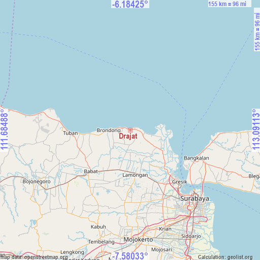
Drajat GPS coordinates[2]
6° 52' 58.08" South, 112° 23' 16.8" East
| Map corner | latitude | longitude |
|---|---|---|
| Upper-left | -6.18425°, | 111.68488° |
| Center: | -6.8828°, | 112.388° |
| Lower-right: | -7.58033°, | 113.09113° |
| Map W x H: | 155.2×155.2 km | = 96.4×96.4mi |
| max Lat: | 5.88969° ⇑26.2% North |
| Drajat: | -6.8828° |
| min Lat: | ⇓73.8% South -10.934° |
| min Long | Drajat | max Long |
| 95.1345° | 112.388° | 140.9419° |
| W 53.2%⇐ | ⇒46.8% E |
Elevation
Elevation of Drajat is 7 m = 23 ft, and this is 222.7 m = 731 ft below average elevation for this country.
| Max E: |
3185 m = 10449 ft | 95.5% |
| Avg. | 229.7 m = 754 ft | |
| Drajat | 7 m = 23 ft | |
Min E: |
-1 m = -3 ft | 4.5% |
See also: Indonesia elevation on elevation.city.
Geographical zone
Drajat is located in South Torrid zone (between Equator and Tropic of Capricorn). Distance of Equator is 765.3 km =475.5 mi to North.| Distance of | km | miles | from Drajat |
|---|---|---|---|
| Equator | 765.3 | 475.5 | to North |
| Tropic Capricorn | 1840.6 | 1143.7 | to South |
| Antarctic Circle | 6635.9 | 4123.4 | to South |
| South Pole | 9241.8 | 5742.6 | to South |


Nearby cities:
15 places around Drajat: (largest is in red/bold)
• Banjaranyar
0.6 km =0.4 mi,  22°
22°
• Banyubang
5.7 km =3.5 mi,  148°
148°
• Bluri
5 km =3.1 mi,  134°
134°
• Dagan
4.6 km =2.9 mi,  144°
144°
• Kemantren
1.9 km =1.2 mi,  63°
63°
• Kranji
0.8 km =0.5 mi,  316°
316°
• Paciran
1.5 km =0.9 mi,  297°
297°
• Payaman
5.4 km =3.4 mi,  225°
225°
• Sendangagung
5 km =3.1 mi,  248°
248°
• Sendangduwur
4.7 km =2.9 mi, 251°
• Sentul
4.7 km =2.9 mi,  88°
88°
• Solokuro
6.6 km =4.1 mi,  212°
212°
• Sumurgayam
4.9 km =3 mi,  267°
267°
• Tlogosadang
6.1 km =3.8 mi, 94°
• Tunggul
1.7 km =1.1 mi, 296°
Sources, notices
• [Note1] Compared only with cities in Indonesia existing in our database
• [Src1] Map data: © OpenStreetMap contributors (CC-BY-SA)
• [Src2] Other city data from geonames.org with taken over terms of usage.
• [Src3] Geographical zone / Annual Mean Temperature by Robert A. Rohde @ Wikipedia
