Imaan geodata
Imaan (East Java) is a seat of a fourth-order administrative division; located in Indonesia in Asia/Jakarta (GMT+7) time zone. In our database, there are 407 cities with bigger population. Compared to other cities in Indonesia, 67.3% of cities are located further ↓South; 54.6% of cities are located further ←West and 89% of cities have higher elevation than Imaan. Note1


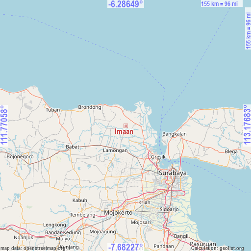
Imaan GPS coordinates[2]
6° 59' 5.64" South, 112° 28' 25.32" East
| Map corner | latitude | longitude |
|---|---|---|
| Upper-left | -6.28649°, | 111.77058° |
| Center: | -6.9849°, | 112.4737° |
| Lower-right: | -7.68227°, | 113.17683° |
| Map W x H: | 155.2×155.2 km | = 96.4×96.4mi |
| max Lat: | 5.88969° ⇑32.7% North |
| Imaan: | -6.9849° |
| min Lat: | ⇓67.3% South -10.934° |
| min Long | Imaan | max Long |
| 95.1345° | 112.4737° | 140.9419° |
| W 54.6%⇐ | ⇒45.4% E |
Elevation
Elevation of Imaan is 11 m = 36 ft, and this is 218.7 m = 718 ft below average elevation for this country.
| Max E: |
3185 m = 10449 ft | 89% |
| Avg. | 229.7 m = 754 ft | |
| Imaan | 11 m = 36 ft | |
Min E: |
-1 m = -3 ft | 11% |
See also: Indonesia elevation on elevation.city.
Geographical zone
Imaan is located in South Torrid zone (between Equator and Tropic of Capricorn). Distance of Equator is 776.6 km =482.6 mi to North.| Distance of | km | miles | from Imaan |
|---|---|---|---|
| Equator | 776.6 | 482.6 | to North |
| Tropic Capricorn | 1829.3 | 1136.7 | to South |
| Antarctic Circle | 6624.5 | 4116.3 | to South |
| South Pole | 9230.4 | 5735.5 | to South |


Nearby cities:
15 places around Imaan: (largest is in red/bold)
• Babakbawo
1.5 km =0.9 mi,  105°
105°
• Banjaranyar
3.3 km =2.1 mi,  203°
203°
• Gedangan
3 km =1.9 mi,  56°
56°
• Jrebeng
2.4 km =1.5 mi, 200°
• Madumulyorejo
3.1 km =1.9 mi,  242°
242°
• Mentaras
3 km =1.9 mi,  277°
277°
• Mojopetung
0.8 km =0.5 mi,  308°
308°
• Petung
1.4 km =0.9 mi,  17°
17°
• Sambogunung
2.7 km =1.7 mi,  98°
98°
• Saniwonorejo
1.9 km =1.2 mi,  87°
87°
• Sukodono
3.5 km =2.2 mi,  327°
327°
• Sukorejo
2.9 km =1.8 mi,  83°
83°
• Sumampir
3.7 km =2.3 mi, 243°
• Watangan
3.5 km =2.2 mi,  160°
160°
• Wotan
3.2 km =2 mi,  25°
25°
Sources, notices
• [Note1] Compared only with cities in Indonesia existing in our database
• [Src1] Map data: © OpenStreetMap contributors (CC-BY-SA)
• [Src2] Other city data from geonames.org with taken over terms of usage.
• [Src3] Geographical zone / Annual Mean Temperature by Robert A. Rohde @ Wikipedia
