Sedagaran geodata
Sedagaran (East Java) is a seat of a fourth-order administrative division; located in Indonesia in Asia/Jakarta (GMT+7) time zone. In our database, there are 407 cities with bigger population. Compared to other cities in Indonesia, 67.2% of cities are located further ↓South; 55.7% of cities are located further ←West and 98.5% of cities have higher elevation than Sedagaran. Note1


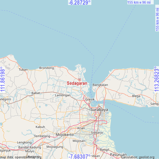
Sedagaran GPS coordinates[2]
6° 59' 8.52" South, 112° 33' 54.36" East
| Map corner | latitude | longitude |
|---|---|---|
| Upper-left | -6.28729°, | 111.86198° |
| Center: | -6.9857°, | 112.5651° |
| Lower-right: | -7.68307°, | 113.26823° |
| Map W x H: | 155.2×155.2 km | = 96.4×96.4mi |
| max Lat: | 5.88969° ⇑32.8% North |
| Sedagaran: | -6.9857° |
| min Lat: | ⇓67.2% South -10.934° |
| min Long | Sedagaran | max Long |
| 95.1345° | 112.5651° | 140.9419° |
| W 55.7%⇐ | ⇒44.3% E |
Elevation
Elevation of Sedagaran is 5 m = 16 ft, and this is 224.7 m = 737 ft below average elevation for this country.
| Max E: |
3185 m = 10449 ft | 98.5% |
| Avg. | 229.7 m = 754 ft | |
| Sedagaran | 5 m = 16 ft | |
Min E: |
-1 m = -3 ft | 1.5% |
See also: Indonesia elevation on elevation.city.
Geographical zone
Sedagaran is located in South Torrid zone (between Equator and Tropic of Capricorn). Distance of Equator is 776.7 km =482.6 mi to North.| Distance of | km | miles | from Sedagaran |
|---|---|---|---|
| Equator | 776.7 | 482.6 | to North |
| Tropic Capricorn | 1829.2 | 1136.6 | to South |
| Antarctic Circle | 6624.4 | 4116.2 | to South |
| South Pole | 9230.3 | 5735.4 | to South |


Nearby cities:
15 places around Sedagaran: (largest is in red/bold)
• Asemanis
1.8 km =1.1 mi,  141°
141°
• Asempapak
1 km =0.6 mi,  185°
185°
• Bunderan
0.7 km =0.4 mi,  215°
215°
• Golokan
3 km =1.9 mi,  285°
285°
• Kauman
0.5 km =0.3 mi,  203°
203°
• Mojoasem
1.5 km =0.9 mi, 144°
• Mriyunan
0.5 km =0.3 mi,  164°
164°
• Pengulu
0.3 km =0.2 mi,  228°
228°
• Purwodadi
0.3 km =0.2 mi,  272°
272°
• Raci Kulon
3 km =1.9 mi,  236°
236°
• Randuboto
2.7 km =1.7 mi, 137°
• Sidayu
1.5 km =0.9 mi, 186°
• Sidomulyo
0.8 km =0.5 mi, 185°
• Sidomulyo
2.5 km =1.6 mi,  323°
323°
• Srowo
0.2 km =0.1 mi,  339°
339°
Sources, notices
• [Note1] Compared only with cities in Indonesia existing in our database
• [Src1] Map data: © OpenStreetMap contributors (CC-BY-SA)
• [Src2] Other city data from geonames.org with taken over terms of usage.
• [Src3] Geographical zone / Annual Mean Temperature by Robert A. Rohde @ Wikipedia
