Glagahan geodata
Glagahan (East Java) is a seat of a fourth-order administrative division; located in Indonesia in Asia/Jakarta (GMT+7) time zone. In our database, there are 407 cities with bigger population. Compared to other cities in Indonesia, 76.5% of cities are located further ↑North; 58.7% of cities are located further ←West and 80.9% of cities have higher elevation than Glagahan. Note1


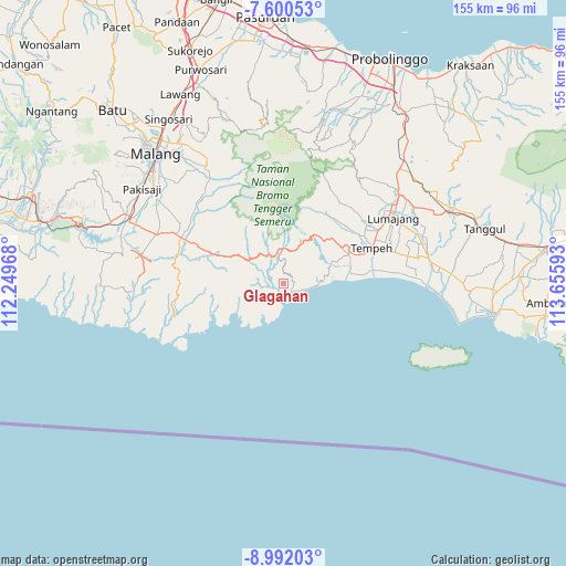
Glagahan GPS coordinates[2]
8° 17' 48.84" South, 112° 57' 10.08" East
| Map corner | latitude | longitude |
|---|---|---|
| Upper-left | -7.60053°, | 112.24968° |
| Center: | -8.2969°, | 112.9528° |
| Lower-right: | -8.99203°, | 113.65593° |
| Map W x H: | 154.7×154.7 km | = 96.1×96.1mi |
| max Lat: | 5.88969° ⇑76.5% North |
| Glagahan: | -8.2969° |
| min Lat: | ⇓23.5% South -10.934° |
| min Long | Glagahan | max Long |
| 95.1345° | 112.9528° | 140.9419° |
| W 58.7%⇐ | ⇒41.3% E |
Elevation
Elevation of Glagahan is 18 m = 59 ft, and this is 211.7 m = 695 ft below average elevation for this country.
| Max E: |
3185 m = 10449 ft | 80.9% |
| Avg. | 229.7 m = 754 ft | |
| Glagahan | 18 m = 59 ft | |
Min E: |
-1 m = -3 ft | 19.1% |
See also: Indonesia elevation on elevation.city.
Geographical zone
Glagahan is located in South Torrid zone (between Equator and Tropic of Capricorn). Distance of Equator is 922.5 km =573.2 mi to North.| Distance of | km | miles | from Glagahan |
|---|---|---|---|
| Equator | 922.5 | 573.2 | to North |
| Tropic Capricorn | 1683.4 | 1046 | to South |
| Antarctic Circle | 6478.6 | 4025.6 | to South |
| South Pole | 9084.5 | 5644.8 | to South |


Nearby cities:
15 places around Glagahan: (largest is in red/bold)
• Boncis
9.9 km =6.2 mi,  292°
292°
• Gampingan
11.7 km =7.3 mi,  264°
264°
• Kaliuling
3.3 km =2.1 mi,  357°
357°
• Krajan Pundungsari
3 km =1.9 mi,  48°
48°
• Krajan Satu B Lebakharjo
5.5 km =3.4 mi, 264°
• Krajan Tempursari
2.4 km =1.5 mi,  75°
75°
• Pujiharjo
11 km =6.8 mi,  224°
224°
• Purorejo
1 km =0.6 mi, 217°
• Purwodadi Lor
13.4 km =8.3 mi,  241°
241°
• Sumberbuncis
8.3 km =5.2 mi, 290°
• Sumbersarikrajan
12.3 km =7.6 mi,  268°
268°
• Tegalrejo
3.6 km =2.2 mi,  182°
182°
• Tempursari
3.1 km =1.9 mi,  68°
68°
• Umbulsari
1.2 km =0.7 mi,  193°
193°
• Wirotaman
12.2 km =7.6 mi, 293°
Sources, notices
• [Note1] Compared only with cities in Indonesia existing in our database
• [Src1] Map data: © OpenStreetMap contributors (CC-BY-SA)
• [Src2] Other city data from geonames.org with taken over terms of usage.
• [Src3] Geographical zone / Annual Mean Temperature by Robert A. Rohde @ Wikipedia
