Tanjungrejo Lor geodata
Tanjungrejo Lor (East Java) is a seat of a fourth-order administrative division; located in Indonesia in Asia/Jakarta (GMT+7) time zone. In our database, there are 407 cities with bigger population. Compared to other cities in Indonesia, 75% of cities are located further ↑North; 60.9% of cities are located further ←West and 89% of cities have higher elevation than Tanjungrejo Lor. Note1


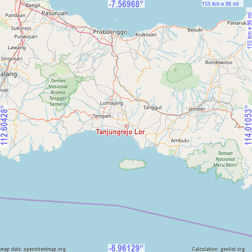
Tanjungrejo Lor GPS coordinates[2]
8° 15' 57.96" South, 113° 18' 26.64" East
| Map corner | latitude | longitude |
|---|---|---|
| Upper-left | -7.56968°, | 112.60428° |
| Center: | -8.2661°, | 113.3074° |
| Lower-right: | -8.96129°, | 114.01053° |
| Map W x H: | 154.7×154.7 km | = 96.1×96.1mi |
| max Lat: | 5.88969° ⇑75% North |
| Tanjungrejo Lor: | -8.2661° |
| min Lat: | ⇓25% South -10.934° |
| min Long | Tanjungrejo Lor | max Long |
| 95.1345° | 113.3074° | 140.9419° |
| W 60.9%⇐ | ⇒39.1% E |
Elevation
Elevation of Tanjungrejo Lor is 11 m = 36 ft, and this is 218.7 m = 718 ft below average elevation for this country.
| Max E: |
3185 m = 10449 ft | 89% |
| Avg. | 229.7 m = 754 ft | |
| Tanjungrejo Lor | 11 m = 36 ft | |
Min E: |
-1 m = -3 ft | 11% |
See also: Indonesia elevation on elevation.city.
Geographical zone
Tanjungrejo Lor is located in South Torrid zone (between Equator and Tropic of Capricorn). Distance of Equator is 919.1 km =571.1 mi to North.| Distance of | km | miles | from Tanjungrejo Lor |
|---|---|---|---|
| Equator | 919.1 | 571.1 | to North |
| Tropic Capricorn | 1686.8 | 1048.1 | to South |
| Antarctic Circle | 6482.1 | 4027.8 | to South |
| South Pole | 9088 | 5647 | to South |


Nearby cities:
15 places around Tanjungrejo Lor: (largest is in red/bold)
• Darungan
6 km =3.7 mi,  288°
288°
• Igir-igir
3.7 km =2.3 mi,  121°
121°
• Jombang
3.7 km =2.3 mi,  351°
351°
• Karangsari
6.6 km =4.1 mi,  310°
310°
• Kebonsari
2.3 km =1.4 mi,  17°
17°
• Krajan Dua Keting
2.2 km =1.4 mi,  79°
79°
• Krajan Dua Padomasan
4.2 km =2.6 mi, 18°
• Krajan Krai
4.7 km =2.9 mi, 309°
• Kraton
5.9 km =3.7 mi,  129°
129°
• Pondokrejo
6.6 km =4.1 mi,  2°
2°
• Sebaren
5.6 km =3.5 mi,  55°
55°
• Sidomulyo
4.1 km =2.5 mi,  281°
281°
• Sidomulyo
5.6 km =3.5 mi,  151°
151°
• Wotgalih
3.1 km =1.9 mi,  262°
262°
• Yosowilangun
3.1 km =1.9 mi,  12°
12°
Sources, notices
• [Note1] Compared only with cities in Indonesia existing in our database
• [Src1] Map data: © OpenStreetMap contributors (CC-BY-SA)
• [Src2] Other city data from geonames.org with taken over terms of usage.
• [Src3] Geographical zone / Annual Mean Temperature by Robert A. Rohde @ Wikipedia
