Yosowilangun geodata
Yosowilangun (East Java) is a seat of a third-order administrative division; located in Indonesia in Asia/Jakarta (GMT+7) time zone. In our database, there are 407 cities with bigger population. Compared to other cities in Indonesia, 73.8% of cities are located further ↑North; 60.9% of cities are located further ←West and 84.2% of cities have higher elevation than Yosowilangun. Note1


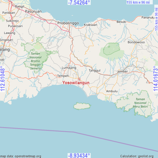
Yosowilangun GPS coordinates[2]
8° 14' 20.76" South, 113° 18' 48.96" East
| Map corner | latitude | longitude |
|---|---|---|
| Upper-left | -7.54264°, | 112.61048° |
| Center: | -8.2391°, | 113.3136° |
| Lower-right: | -8.93434°, | 114.01673° |
| Map W x H: | 154.7×154.7 km | = 96.1×96.1mi |
| max Lat: | 5.88969° ⇑73.8% North |
| Yosowilangun: | -8.2391° |
| min Lat: | ⇓26.2% South -10.934° |
| min Long | Yosowilangun | max Long |
| 95.1345° | 113.3136° | 140.9419° |
| W 60.9%⇐ | ⇒39.1% E |
Elevation
Elevation of Yosowilangun is 15 m = 49 ft, and this is 214.7 m = 704 ft below average elevation for this country.
| Max E: |
3185 m = 10449 ft | 84.2% |
| Avg. | 229.7 m = 754 ft | |
| Yosowilangun | 15 m = 49 ft | |
Min E: |
-1 m = -3 ft | 15.8% |
See also: Indonesia elevation on elevation.city.
Geographical zone
Yosowilangun is located in South Torrid zone (between Equator and Tropic of Capricorn). Distance of Equator is 916.1 km =569.2 mi to North.| Distance of | km | miles | from Yosowilangun |
|---|---|---|---|
| Equator | 916.1 | 569.2 | to North |
| Tropic Capricorn | 1689.8 | 1050 | to South |
| Antarctic Circle | 6485.1 | 4029.7 | to South |
| South Pole | 9091 | 5648.9 | to South |


Nearby cities:
15 places around Yosowilangun: (largest is in red/bold)
• Igir-igir
5.5 km =3.4 mi,  153°
153°
• Jombang
1.4 km =0.9 mi,  299°
299°
• Karangsari
5.8 km =3.6 mi,  283°
283°
• Kebonsari
0.8 km =0.5 mi,  178°
178°
• Krajan Dua Keting
3 km =1.9 mi, 151°
• Krajan Dua Padomasan
1.1 km =0.7 mi,  33°
33°
• Krajan Krai
4.3 km =2.7 mi,  269°
269°
• Krajan Rowokangkung
5.5 km =3.4 mi,  24°
24°
• Nogosari
6.1 km =3.8 mi,  338°
338°
• Pondokrejo
3.6 km =2.2 mi,  353°
353°
• Rowokangkung
5.3 km =3.3 mi, 19°
• Sebaren
3.9 km =2.4 mi,  86°
86°
• Sidomulyo
5.2 km =3.2 mi,  245°
245°
• Tanjungrejo Lor
3.1 km =1.9 mi,  192°
192°
• Wotgalih
5.1 km =3.2 mi,  227°
227°
Sources, notices
• [Note1] Compared only with cities in Indonesia existing in our database
• [Src1] Map data: © OpenStreetMap contributors (CC-BY-SA)
• [Src2] Other city data from geonames.org with taken over terms of usage.
• [Src3] Geographical zone / Annual Mean Temperature by Robert A. Rohde @ Wikipedia
