Rowotamtu geodata
Rowotamtu (East Java) is a seat of a fourth-order administrative division; located in Indonesia in Asia/Jakarta (GMT+7) time zone. In our database, there are 407 cities with bigger population. Compared to other cities in Indonesia, 73.4% of cities are located further ↑North; 63.2% of cities are located further ←West and 65.2% of cities have higher elevation than Rowotamtu. Note1


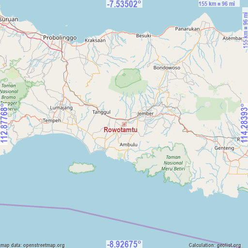
Rowotamtu GPS coordinates[2]
8° 13' 53.4" South, 113° 34' 50.88" East
| Map corner | latitude | longitude |
|---|---|---|
| Upper-left | -7.53502°, | 112.87768° |
| Center: | -8.2315°, | 113.5808° |
| Lower-right: | -8.92675°, | 114.28393° |
| Map W x H: | 154.7×154.7 km | = 96.1×96.1mi |
| max Lat: | 5.88969° ⇑73.4% North |
| Rowotamtu: | -8.2315° |
| min Lat: | ⇓26.6% South -10.934° |
| min Long | Rowotamtu | max Long |
| 95.1345° | 113.5808° | 140.9419° |
| W 63.2%⇐ | ⇒36.8% E |
Elevation
Elevation of Rowotamtu is 42 m = 138 ft, and this is 187.7 m = 616 ft below average elevation for this country.
| Max E: |
3185 m = 10449 ft | 65.2% |
| Avg. | 229.7 m = 754 ft | |
| Rowotamtu | 42 m = 138 ft | |
Min E: |
-1 m = -3 ft | 34.8% |
See also: Indonesia elevation on elevation.city.
Geographical zone
Rowotamtu is located in South Torrid zone (between Equator and Tropic of Capricorn). Distance of Equator is 915.3 km =568.7 mi to North.| Distance of | km | miles | from Rowotamtu |
|---|---|---|---|
| Equator | 915.3 | 568.7 | to North |
| Tropic Capricorn | 1690.7 | 1050.6 | to South |
| Antarctic Circle | 6485.9 | 4030.2 | to South |
| South Pole | 9091.8 | 5649.4 | to South |


Nearby cities:
15 places around Rowotamtu: (largest is in red/bold)
• Bangsalsari
6 km =3.7 mi,  302°
302°
• Bedadung Kulon
3.2 km =2 mi,  66°
66°
• Curahlele Wetan
4.1 km =2.5 mi,  248°
248°
• Dukuhsia
5.8 km =3.6 mi,  45°
45°
• Glundengankrajan
6.1 km =3.8 mi,  205°
205°
• Gugut
6.3 km =3.9 mi,  33°
33°
• Gumawang
1.6 km =1 mi,  233°
233°
• Gunungsari
3.8 km =2.4 mi, 206°
• Jetis
3.8 km =2.4 mi,  332°
332°
• Krajan Lor Gumelar
4.1 km =2.5 mi, 231°
• Langkap
4.2 km =2.6 mi,  319°
319°
• Pecoro
2.8 km =1.7 mi,  24°
24°
• Petung
2.8 km =1.7 mi,  3°
3°
• Rambipuji
4 km =2.5 mi, 51°
• Sukorejo
5.8 km =3.6 mi,  279°
279°
Sources, notices
• [Note1] Compared only with cities in Indonesia existing in our database
• [Src1] Map data: © OpenStreetMap contributors (CC-BY-SA)
• [Src2] Other city data from geonames.org with taken over terms of usage.
• [Src3] Geographical zone / Annual Mean Temperature by Robert A. Rohde @ Wikipedia
