Gontar geodata
Gontar (West Nusa Tenggara) is a seat of a fourth-order administrative division; located in Indonesia in Asia/Makassar (GMT+8) time zone. In our database, there are 407 cities with bigger population. Compared to other cities in Indonesia, 83.9% of cities are located further ↑North; 78.4% of cities are located further ←West and 87.7% of cities have higher elevation than Gontar. Note1


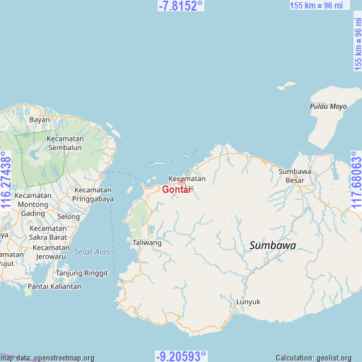
Gontar GPS coordinates[2]
8° 30' 40.32" South, 116° 58' 39" East
| Map corner | latitude | longitude |
|---|---|---|
| Upper-left | -7.8152°, | 116.27438° |
| Center: | -8.5112°, | 116.9775° |
| Lower-right: | -9.20593°, | 117.68063° |
| Map W x H: | 154.6×154.6 km | = 96.1×96.1mi |
| max Lat: | 5.88969° ⇑83.9% North |
| Gontar: | -8.5112° |
| min Lat: | ⇓16.1% South -10.934° |
| min Long | Gontar | max Long |
| 95.1345° | 116.9775° | 140.9419° |
| W 78.4%⇐ | ⇒21.6% E |
Elevation
Elevation of Gontar is 12 m = 39 ft, and this is 217.7 m = 714 ft below average elevation for this country.
| Max E: |
3185 m = 10449 ft | 87.7% |
| Avg. | 229.7 m = 754 ft | |
| Gontar | 12 m = 39 ft | |
Min E: |
-1 m = -3 ft | 12.3% |
See also: Indonesia elevation on elevation.city.
Geographical zone
Gontar is located in South Torrid zone (between Equator and Tropic of Capricorn). Distance of Equator is 946.4 km =588.1 mi to North.| Distance of | km | miles | from Gontar |
|---|---|---|---|
| Equator | 946.4 | 588.1 | to North |
| Tropic Capricorn | 1659.6 | 1031.2 | to South |
| Antarctic Circle | 6454.8 | 4010.8 | to South |
| South Pole | 9060.7 | 5630.1 | to South |


Nearby cities:
15 places around Gontar: (largest is in red/bold)
• Baru
2.1 km =1.3 mi,  127°
127°
• Dalam
2 km =1.2 mi,  103°
103°
• Juranalas
2.5 km =1.6 mi,  121°
121°
• Kalimango
2.3 km =1.4 mi, 121°
• Labuhanmapin
4.2 km =2.6 mi,  257°
257°
• Lekong
2.9 km =1.8 mi,  206°
206°
• Luar
1.9 km =1.2 mi, 116°
• Mapinkebak
5.8 km =3.6 mi,  222°
222°
• Mapinrea
6.4 km =4 mi, 212°
• Marenteh
6 km =3.7 mi, 131°
• Rempe
19.4 km =12.1 mi, 218°
• Senayan
18 km =11.2 mi,  231°
231°
• Seteluk
17.6 km =10.9 mi, 223°
• Seteluk Atas
17.6 km =10.9 mi, 222°
• Seteluk Tengah
17.9 km =11.1 mi, 224°
Sources, notices
• [Note1] Compared only with cities in Indonesia existing in our database
• [Src1] Map data: © OpenStreetMap contributors (CC-BY-SA)
• [Src2] Other city data from geonames.org with taken over terms of usage.
• [Src3] Geographical zone / Annual Mean Temperature by Robert A. Rohde @ Wikipedia
