Labuhanmapin geodata
Labuhanmapin (West Nusa Tenggara) is a seat of a fourth-order administrative division; located in Indonesia in Asia/Makassar (GMT+8) time zone. In our database, there are 407 cities with bigger population. Compared to other cities in Indonesia, 84.2% of cities are located further ↑North; 78.3% of cities are located further ←West and 97.2% of cities have higher elevation than Labuhanmapin. Note1


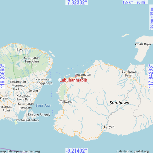
Labuhanmapin GPS coordinates[2]
8° 31' 9.48" South, 116° 56' 23.28" East
| Map corner | latitude | longitude |
|---|---|---|
| Upper-left | -7.82332°, | 116.23668° |
| Center: | -8.5193°, | 116.9398° |
| Lower-right: | -9.21402°, | 117.64293° |
| Map W x H: | 154.6×154.6 km | = 96.1×96.1mi |
| max Lat: | 5.88969° ⇑84.2% North |
| Labuhanmapin: | -8.5193° |
| min Lat: | ⇓15.8% South -10.934° |
| min Long | Labuhanmapin | max Long |
| 95.1345° | 116.9398° | 140.9419° |
| W 78.3%⇐ | ⇒21.7% E |
Elevation
Elevation of Labuhanmapin is 6 m = 20 ft, and this is 223.7 m = 734 ft below average elevation for this country.
| Max E: |
3185 m = 10449 ft | 97.2% |
| Avg. | 229.7 m = 754 ft | |
| Labuhanmapin | 6 m = 20 ft | |
Min E: |
-1 m = -3 ft | 2.8% |
See also: Indonesia elevation on elevation.city.
Geographical zone
Labuhanmapin is located in South Torrid zone (between Equator and Tropic of Capricorn). Distance of Equator is 947.3 km =588.6 mi to North.| Distance of | km | miles | from Labuhanmapin |
|---|---|---|---|
| Equator | 947.3 | 588.6 | to North |
| Tropic Capricorn | 1658.7 | 1030.7 | to South |
| Antarctic Circle | 6453.9 | 4010.3 | to South |
| South Pole | 9059.8 | 5629.5 | to South |


Nearby cities:
15 places around Labuhanmapin: (largest is in red/bold)
• Baru
5.8 km =3.6 mi,  93°
93°
• Dalam
6.1 km =3.8 mi, 86°
• Gontar
4.2 km =2.6 mi,  77°
77°
• Juranalas
6.3 km =3.9 mi, 93°
• Kalimango
6.1 km =3.8 mi, 92°
• Lekong
3.3 km =2.1 mi,  120°
120°
• Luar
5.9 km =3.7 mi, 89°
• Mapinkebak
3.4 km =2.1 mi,  176°
176°
• Mapinrea
4.5 km =2.8 mi,  170°
170°
• Marenteh
9.2 km =5.7 mi,  109°
109°
• Rempe
16.4 km =10.2 mi,  209°
209°
• Senayan
14.3 km =8.9 mi,  223°
223°
• Seteluk
14.3 km =8.9 mi, 214°
• Seteluk Atas
14.4 km =8.9 mi, 212°
• Seteluk Tengah
14.5 km =9 mi, 214°
Sources, notices
• [Note1] Compared only with cities in Indonesia existing in our database
• [Src1] Map data: © OpenStreetMap contributors (CC-BY-SA)
• [Src2] Other city data from geonames.org with taken over terms of usage.
• [Src3] Geographical zone / Annual Mean Temperature by Robert A. Rohde @ Wikipedia
