Kembang geodata
Kembang (East Java) is a seat of a fourth-order administrative division; located in Indonesia in Asia/Jakarta (GMT+7) time zone. In our database, there are 407 cities with bigger population. Compared to other cities in Indonesia, 64% of cities are located further ↑North; 57.8% of cities are located further →East and 94.7% of cities have lower elevation than Kembang. Note1


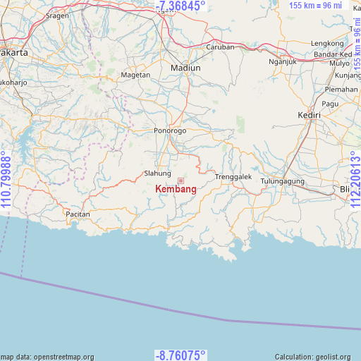
Kembang GPS coordinates[2]
8° 3' 54.72" South, 111° 30' 10.8" East
| Map corner | latitude | longitude |
|---|---|---|
| Upper-left | -7.36845°, | 110.79988° |
| Center: | -8.0652°, | 111.503° |
| Lower-right: | -8.76075°, | 112.20613° |
| Map W x H: | 154.8×154.8 km | = 96.2×96.2mi |
| max Lat: | 5.88969° ⇑64% North |
| Kembang: | -8.0652° |
| min Lat: | ⇓36% South -10.934° |
| min Long | Kembang | max Long |
| 95.1345° | 111.503° | 140.9419° |
| W 42.2%⇐ | ⇒57.8% E |
Elevation
Elevation of Kembang is 803 m = 2635 ft, and this is 573.3 m = 1881 ft above average elevation for this country.
| Max E: |
3185 m = 10449 ft | 5.3% |
| Kembang | 803 m 2635 ft | |
| Avg. | 229.7 m = 754 ft | |
Min E: |
-1 m = -3 ft | 94.7% |
See also: Indonesia elevation on elevation.city.
Geographical zone
Kembang is located in South Torrid zone (between Equator and Tropic of Capricorn). Distance of Equator is 896.8 km =557.2 mi to North.| Distance of | km | miles | from Kembang |
|---|---|---|---|
| Equator | 896.8 | 557.2 | to North |
| Tropic Capricorn | 1709.2 | 1062 | to South |
| Antarctic Circle | 6504.4 | 4041.6 | to South |
| South Pole | 9110.3 | 5660.9 | to South |


Nearby cities:
15 places around Kembang: (largest is in red/bold)
• Bibis
7.4 km =4.6 mi,  327°
327°
• Gabahan
7.6 km =4.7 mi,  312°
312°
• Gondang
7.4 km =4.6 mi,  59°
59°
• Klatakan
7.9 km =4.9 mi, 325°
• Krajan Karanganyar
6.8 km =4.2 mi,  107°
107°
• Krajan Selur
4.9 km =3 mi,  228°
228°
• Krajan Tenggaran
5.9 km =3.7 mi,  117°
117°
• Munung
6 km =3.7 mi, 311°
• Nglorogan
5.4 km =3.4 mi, 234°
• Ngrayun
6 km =3.7 mi,  262°
262°
• Pelem Satu
5.5 km =3.4 mi,  295°
295°
• Pule
3.1 km =1.9 mi,  358°
358°
• Puyung
6.9 km =4.3 mi,  186°
186°
• Sidomulyo
8.1 km =5 mi,  197°
197°
• Tiron
6.7 km =4.2 mi, 305°
Sources, notices
• [Note1] Compared only with cities in Indonesia existing in our database
• [Src1] Map data: © OpenStreetMap contributors (CC-BY-SA)
• [Src2] Other city data from geonames.org with taken over terms of usage.
• [Src3] Geographical zone / Annual Mean Temperature by Robert A. Rohde @ Wikipedia
