Gondang geodata
Gondang (East Java) is a seat of a fourth-order administrative division; located in Indonesia in Asia/Jakarta (GMT+7) time zone. In our database, there are 407 cities with bigger population. Compared to other cities in Indonesia, 62.4% of cities are located further ↑North; 56.9% of cities are located further →East and 78.6% of cities have lower elevation than Gondang. Note1


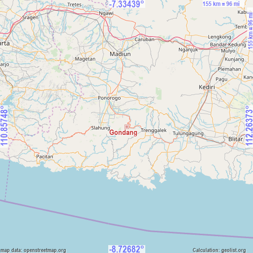
Gondang GPS coordinates[2]
8° 1' 52.32" South, 111° 33' 38.16" East
| Map corner | latitude | longitude |
|---|---|---|
| Upper-left | -7.33439°, | 110.85748° |
| Center: | -8.0312°, | 111.5606° |
| Lower-right: | -8.72682°, | 112.26373° |
| Map W x H: | 154.8×154.8 km | = 96.2×96.2mi |
| max Lat: | 5.88969° ⇑62.4% North |
| Gondang: | -8.0312° |
| min Lat: | ⇓37.6% South -10.934° |
| min Long | Gondang | max Long |
| 95.1345° | 111.5606° | 140.9419° |
| W 43.1%⇐ | ⇒56.9% E |
Elevation
Elevation of Gondang is 406 m = 1332 ft, and this is 176.3 m = 578 ft above average elevation for this country.
| Max E: |
3185 m = 10449 ft | 21.4% |
| Gondang | 406 m 1332 ft | |
| Avg. | 229.7 m = 754 ft | |
Min E: |
-1 m = -3 ft | 78.6% |
See also: Indonesia elevation on elevation.city.
Geographical zone
Gondang is located in South Torrid zone (between Equator and Tropic of Capricorn). Distance of Equator is 893 km =554.9 mi to North.| Distance of | km | miles | from Gondang |
|---|---|---|---|
| Equator | 893 | 554.9 | to North |
| Tropic Capricorn | 1712.9 | 1064.3 | to South |
| Antarctic Circle | 6508.2 | 4044 | to South |
| South Pole | 9114.1 | 5663.2 | to South |


Nearby cities:
15 places around Gondang: (largest is in red/bold)
• Blumbang
2.3 km =1.4 mi,  62°
62°
• Gajah
4.8 km =3 mi,  109°
109°
• Gandu
8 km =5 mi,  143°
143°
• Jambu
8.5 km =5.3 mi,  91°
91°
• Kembang
7.4 km =4.6 mi,  239°
239°
• Krajan Gading
3.8 km =2.4 mi,  74°
74°
• Krajan Karanganyar
5.8 km =3.6 mi,  178°
178°
• Krajan Nglinggis
4.7 km =2.9 mi,  102°
102°
• Krajan Pucanganak
5.5 km =3.4 mi,  84°
84°
• Krajan Suko Kidul
3.8 km =2.4 mi,  147°
147°
• Krajan Tenggaran
6.6 km =4.1 mi,  189°
189°
• Pule
6.5 km =4 mi,  264°
264°
• Sidem
7.7 km =4.8 mi,  161°
161°
• Tegarenkrajan
9.2 km =5.7 mi, 85°
• Tugu
8.3 km =5.2 mi, 86°
Sources, notices
• [Note1] Compared only with cities in Indonesia existing in our database
• [Src1] Map data: © OpenStreetMap contributors (CC-BY-SA)
• [Src2] Other city data from geonames.org with taken over terms of usage.
• [Src3] Geographical zone / Annual Mean Temperature by Robert A. Rohde @ Wikipedia
