Krajan Kerjo geodata
Krajan Kerjo (East Java) is a seat of a fourth-order administrative division; located in Indonesia in Asia/Jakarta (GMT+7) time zone. In our database, there are 407 cities with bigger population. Compared to other cities in Indonesia, 63.8% of cities are located further ↑North; 55.1% of cities are located further →East and 55% of cities have lower elevation than Krajan Kerjo. Note1


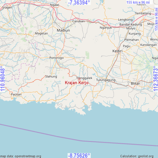
Krajan Kerjo GPS coordinates[2]
8° 3' 38.52" South, 111° 39' 48.96" East
| Map corner | latitude | longitude |
|---|---|---|
| Upper-left | -7.36394°, | 110.96048° |
| Center: | -8.0607°, | 111.6636° |
| Lower-right: | -8.75626°, | 112.36673° |
| Map W x H: | 154.8×154.8 km | = 96.2×96.2mi |
| max Lat: | 5.88969° ⇑63.8% North |
| Krajan Kerjo: | -8.0607° |
| min Lat: | ⇓36.2% South -10.934° |
| min Long | Krajan Kerjo | max Long |
| 95.1345° | 111.6636° | 140.9419° |
| W 44.9%⇐ | ⇒55.1% E |
Elevation
Elevation of Krajan Kerjo is 125 m = 410 ft, and this is 104.7 m = 344 ft below average elevation for this country.
| Max E: |
3185 m = 10449 ft | 45% |
| Avg. | 229.7 m = 754 ft | |
| Krajan Kerjo | 125 m = 410 ft | |
Min E: |
-1 m = -3 ft | 55% |
See also: Indonesia elevation on elevation.city.
Geographical zone
Krajan Kerjo is located in South Torrid zone (between Equator and Tropic of Capricorn). Distance of Equator is 896.3 km =556.9 mi to North.| Distance of | km | miles | from Krajan Kerjo |
|---|---|---|---|
| Equator | 896.3 | 556.9 | to North |
| Tropic Capricorn | 1709.7 | 1062.4 | to South |
| Antarctic Circle | 6504.9 | 4042 | to South |
| South Pole | 9110.8 | 5661.2 | to South |


Nearby cities:
15 places around Krajan Kerjo: (largest is in red/bold)
• Banarankrajan
2.3 km =1.4 mi,  16°
16°
• Banjar
2.5 km =1.6 mi,  140°
140°
• Gondang
1.8 km =1.1 mi,  334°
334°
• Jambu
4.1 km =2.5 mi,  316°
316°
• Karangan
3 km =1.9 mi,  189°
189°
• Kebon
2.2 km =1.4 mi, 333°
• Krajan Winong
3.9 km =2.4 mi, 330°
• Krayen
3.7 km =2.3 mi,  218°
218°
• Ngentrong
2.7 km =1.7 mi,  43°
43°
• Nglongsor
1.5 km =0.9 mi,  354°
354°
• Prambonkrajan
4 km =2.5 mi,  8°
8°
• Rejosari
1.7 km =1.1 mi,  134°
134°
• Sukorejokrajan
3.1 km =1.9 mi, 315°
• Sumberkrajan
2.9 km =1.8 mi,  66°
66°
• Tumpuk
1.9 km =1.2 mi,  289°
289°
Sources, notices
• [Note1] Compared only with cities in Indonesia existing in our database
• [Src1] Map data: © OpenStreetMap contributors (CC-BY-SA)
• [Src2] Other city data from geonames.org with taken over terms of usage.
• [Src3] Geographical zone / Annual Mean Temperature by Robert A. Rohde @ Wikipedia
