Kroyo geodata
Kroyo (East Java) is a seat of a fourth-order administrative division; located in Indonesia in Asia/Jakarta (GMT+7) time zone. In our database, there are 407 cities with bigger population. Compared to other cities in Indonesia, 70.3% of cities are located further ↑North; 53.2% of cities are located further →East and 51.7% of cities have higher elevation than Kroyo. Note1


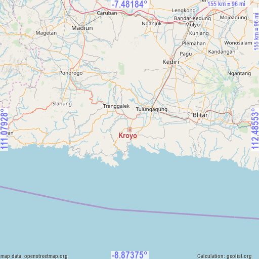
Kroyo GPS coordinates[2]
8° 10' 42.24" South, 111° 46' 56.64" East
| Map corner | latitude | longitude |
|---|---|---|
| Upper-left | -7.48184°, | 111.07928° |
| Center: | -8.1784°, | 111.7824° |
| Lower-right: | -8.87375°, | 112.48553° |
| Map W x H: | 154.8×154.8 km | = 96.2×96.2mi |
| max Lat: | 5.88969° ⇑70.3% North |
| Kroyo: | -8.1784° |
| min Lat: | ⇓29.7% South -10.934° |
| min Long | Kroyo | max Long |
| 95.1345° | 111.7824° | 140.9419° |
| W 46.8%⇐ | ⇒53.2% E |
Elevation
Elevation of Kroyo is 96 m = 315 ft, and this is 133.7 m = 439 ft below average elevation for this country.
| Max E: |
3185 m = 10449 ft | 51.7% |
| Avg. | 229.7 m = 754 ft | |
| Kroyo | 96 m = 315 ft | |
Min E: |
-1 m = -3 ft | 48.3% |
See also: Indonesia elevation on elevation.city.
Geographical zone
Kroyo is located in South Torrid zone (between Equator and Tropic of Capricorn). Distance of Equator is 909.4 km =565.1 mi to North.| Distance of | km | miles | from Kroyo |
|---|---|---|---|
| Equator | 909.4 | 565.1 | to North |
| Tropic Capricorn | 1696.6 | 1054.2 | to South |
| Antarctic Circle | 6491.8 | 4033.8 | to South |
| South Pole | 9097.7 | 5653 | to South |


Nearby cities:
15 places around Kroyo: (largest is in red/bold)
• Bagusan
2.1 km =1.3 mi,  272°
272°
• Bakalan
1.4 km =0.9 mi,  48°
48°
• Bandung
1.2 km =0.7 mi,  10°
10°
• Contong
0.8 km =0.5 mi,  22°
22°
• Kedungbuntung
1.9 km =1.2 mi,  294°
294°
• Kundung
1.7 km =1.1 mi,  200°
200°
• Mergayu
1 km =0.6 mi,  356°
356°
• Mulyo
1.9 km =1.2 mi,  65°
65°
• Ngunggahan
0.6 km =0.4 mi,  78°
78°
• Sebalor
3.1 km =1.9 mi,  308°
308°
• Sidomulyo
3 km =1.9 mi,  88°
88°
• Singgit
2.8 km =1.7 mi,  344°
344°
• Sukoanyar
2.8 km =1.7 mi, 71°
• Suruhan Lor
2.7 km =1.7 mi, 14°
• Suwaru
0.4 km =0.2 mi,  330°
330°
Sources, notices
• [Note1] Compared only with cities in Indonesia existing in our database
• [Src1] Map data: © OpenStreetMap contributors (CC-BY-SA)
• [Src2] Other city data from geonames.org with taken over terms of usage.
• [Src3] Geographical zone / Annual Mean Temperature by Robert A. Rohde @ Wikipedia
