Ngunggahan geodata
Ngunggahan (East Java) is a seat of a fourth-order administrative division; located in Indonesia in Asia/Jakarta (GMT+7) time zone. In our database, there are 407 cities with bigger population. Compared to other cities in Indonesia, 70.2% of cities are located further ↑North; 53.1% of cities are located further →East and 54.3% of cities have higher elevation than Ngunggahan. Note1


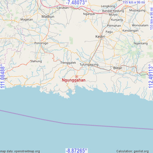
Ngunggahan GPS coordinates[2]
8° 10' 38.28" South, 111° 47' 16.8" East
| Map corner | latitude | longitude |
|---|---|---|
| Upper-left | -7.48073°, | 111.08488° |
| Center: | -8.1773°, | 111.788° |
| Lower-right: | -8.87265°, | 112.49113° |
| Map W x H: | 154.8×154.8 km | = 96.2×96.2mi |
| max Lat: | 5.88969° ⇑70.2% North |
| Ngunggahan: | -8.1773° |
| min Lat: | ⇓29.8% South -10.934° |
| min Long | Ngunggahan | max Long |
| 95.1345° | 111.788° | 140.9419° |
| W 46.9%⇐ | ⇒53.1% E |
Elevation
Elevation of Ngunggahan is 88 m = 289 ft, and this is 141.7 m = 465 ft below average elevation for this country.
| Max E: |
3185 m = 10449 ft | 54.3% |
| Avg. | 229.7 m = 754 ft | |
| Ngunggahan | 88 m = 289 ft | |
Min E: |
-1 m = -3 ft | 45.7% |
See also: Indonesia elevation on elevation.city.
Geographical zone
Ngunggahan is located in South Torrid zone (between Equator and Tropic of Capricorn). Distance of Equator is 909.2 km =565 mi to North.| Distance of | km | miles | from Ngunggahan |
|---|---|---|---|
| Equator | 909.2 | 565 | to North |
| Tropic Capricorn | 1696.7 | 1054.3 | to South |
| Antarctic Circle | 6491.9 | 4033.9 | to South |
| South Pole | 9097.8 | 5653.1 | to South |


Nearby cities:
15 places around Ngunggahan: (largest is in red/bold)
• Bagusan
2.7 km =1.7 mi,  269°
269°
• Bakalan
0.9 km =0.6 mi,  27°
27°
• Bandung
1.1 km =0.7 mi,  339°
339°
• Contong
0.7 km =0.4 mi, 335°
• Gombang
2.8 km =1.7 mi,  39°
39°
• Kedungbuntung
2.4 km =1.5 mi,  285°
285°
• Kroyo
0.6 km =0.4 mi,  258°
258°
• Kundung
2.1 km =1.3 mi,  215°
215°
• Mergayu
1.1 km =0.7 mi,  322°
322°
• Mulyo
1.3 km =0.8 mi,  59°
59°
• Sidomulyo
2.3 km =1.4 mi,  91°
91°
• Singgit
2.9 km =1.8 mi,  332°
332°
• Sukoanyar
2.2 km =1.4 mi,  69°
69°
• Suruhan Lor
2.5 km =1.6 mi,  1°
1°
• Suwaru
0.8 km =0.5 mi,  283°
283°
Sources, notices
• [Note1] Compared only with cities in Indonesia existing in our database
• [Src1] Map data: © OpenStreetMap contributors (CC-BY-SA)
• [Src2] Other city data from geonames.org with taken over terms of usage.
• [Src3] Geographical zone / Annual Mean Temperature by Robert A. Rohde @ Wikipedia
